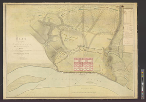
Savannah River and Savannah Sound

This map is also available in American Revolutionary Geographies Online (ARGO), a collections portal especially built for material relating to the American Revolutionary War Era. Visit ARGO to learn more about this item and explore the historical geography of North America in the late eighteenth century.
Item Information
- Title:
- Savannah River and Savannah Sound
- Date:
-
[1770–1779]
- Format:
-
Maps/Atlases
- Genre:
-
Manuscript maps
- Location:
- William L. Clements Library
- Collection (local):
-
William L. Clements Library Collection
- Subjects:
-
Savannah River (Ga. and S.C.)--Maps
Savannah (Ga.)--Maps
United States--History--Revolution, 1775-1783--Maps
- Places:
-
Savannah River
GeorgiaChatham (county)Savannah
- Extent:
- 1 ms. map : col. ; 62.6 x 106 cm.
- Terms of Use:
-
The University of Michigan Library provides access to these materials for educational and research purposes. These materials may be under copyright. If you decide to use any of these materials, you are responsible for making your own legal assessment and securing any necessary permission. If you have questions about the collection, please contact the William L. Clements Library.
Contact host institution for more information.
- Scale:
-
Scale 1:110,000.
- Language:
-
English
- Catalog Record:
-
Catalog record
- Notes:
-
Finished, colored, topographical map showing the sound and a part of the Georgia coastline to the south of the Savannah River and the river from its mouth to modern Screven County.
The plan is very detailed and shows many individual houses, roads, towns, and hamlets.
- Notes (date):
-
This date is inferred.
- Identifier:
-
8301
- Barcode:
-
B2643807
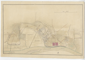
![Plan of the decent [sic] and action of the 29th Decr. 1778, near the town of Savannah; by his majestys forces, under the command of Lt. Colol. Campbell of the 71st Regt. foot](https://bpldcassets.blob.core.windows.net/derivatives/metadata/commonwealth-oai:qj72t576b/image_thumbnail_300.jpg)