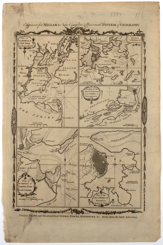
Various plans and draughts of cities, towns, harbours &c. drawn from the latest authorities
This map is also available in American Revolutionary Geographies Online (ARGO), a collections portal especially built for material relating to the American Revolutionary War Era. Visit ARGO to learn more about this item and explore the historical geography of North America in the late eighteenth century.
Item Information
- Title:
- Various plans and draughts of cities, towns, harbours &c. drawn from the latest authorities
- Description:
-
Subject: Five maps showing different harbor cities in the United States and Cuba.
- Date:
-
[1782]
- Format:
-
Maps/Atlases
- Location:
- American Antiquarian Society
- Collection (local):
-
American Antiquarian Society Collection
- Subjects:
-
Boston (Mass.)--Maps
New York (N.Y.)--Maps
Delaware River (N.Y.-Del. and N.J.)--Maps
Charleston (S.C.)--Maps
Havana (Cuba)--Maps
- Places:
-
CubaHavana (province)Havana
Delaware River
New YorkNew York
MassachusettsSuffolk (county)Boston
South CarolinaCharleston (county)Charleston
- Extent:
- 5 maps on 1 sheet : engraving ; maps 15 x 10 cm. or smaller, on sheet 38 x 25 cm.
- Terms of Use:
-
Public Domain/No known restrictions on use. Contact host institution to download image.
Contact host institution for more information.
- Publisher:
-
London :
[s.n.]
- Scale:
-
Scales vary
- Language:
-
English
- Catalog Record:
-
http://catalog.mwa.org/vwebv/holdingsInfo?bibId=483807
- Notes:
-
Relief shown pictorially.
From Millar, G. The new and universal system of geography, London, 1782.
At top: Engraved for Millar's new complete & universal system of geography.
"Plan of the harbour of New-York and parts adjacent -- The town & harbour of Boston &c. -- Draught of the River Delaware from Chester to Philadelphia -- Plan of the harbour of Charles Town, South Carolina -- Plan of the city & harbour of Havanna, capital of Cuba."
- Notes (date):
-
This date is inferred.


![[Plan of New York]](https://bpldcassets.blob.core.windows.net/derivatives/images/commonwealth:6108vt38k/image_thumbnail_300.jpg)

