Toggle navigation
LMEC Home
Exhibitions
Georeferencing
Tools for Teachers
Collections
My Favorites
Sign Up / Log In
Search
Search the map portal
Map Collection
Map Collection
Map Sets
Search
Search
Search for
Search In
All Fields
Creator
Title
Subject
Place
Search All Digital Collections
Advanced Search
134 Results
My Search
Start Over
More Like
commonwealth:q524n611v
Remove constraint More Like: commonwealth:q524n611v
Filter your Search
Place
North and Central America
127
United States
109
New England
90
Massachusetts
31
Middle Atlantic
20
Canada
13
Rhode Island
11
Northeastern United States
10
more
Place
»
Topic
New England--Maps--Early works to 1800
91
Massachusetts--Maps--Early works to 1800
30
Middle Atlantic States--Maps--Early works to 1800
20
Rhode Island--Maps--Early works to 1800
11
Northeastern States--Maps--Early works to 1800
10
Connecticut--Maps--Early works to 1800
8
New York (State)--Maps--Early works to 1800
8
Boston (Mass.)--Maps--Early works to 1800
7
more
Topic
»
Date
Date range begin
–
Date range end
Current results range from
1483
to
1999
View distribution
Creator
Jefferys, Thomas, d. 1771
8
Des Barres, Joseph F. W. (Joseph Frederick Wallet), 1722-1824
5
Bachelder, John B. (John Badger), 1825-1894
4
Bellin, Jacques Nicolas, 1703-1772
4
Green, John, d. 1757
4
Jefferys, Thomas, -1771
4
Bien, Julius, 1826-1909
3
Bowles, Carington, 1724-1793
3
more
Creator
»
Format
Maps/Atlases
129
Manuscripts
5
Photographs
3
Books
1
Documents
1
Georeferenced
Yes
11
No
123
Collection
Norman B. Leventhal Map Center Collection
94
American Revolutionary War-Era Maps
72
Boston and New England Maps
46
Mapping Boston Collection
24
Sidney R. Knafel Map Collection at Phillips Academy
19
Maritime Charts and Atlases
14
Richard H. Brown Revolutionary War Map Collection at Mount Vernon
8
British Library Collection
4
more
Collection
»
Available to use
No known restrictions
70
Creative Commons license
42
Search Constraints
Sort by date (asc)
relevance
title
date (asc)
date (desc)
Number of results to display per page
20 per page
10
per page
20
per page
50
per page
100
per page
View results as:
grid view
map view
Search Results
41.
A map of New England, New York, New Jersey and Pensilvania
42.
Recens edita totius Novi Belgii in America Septentrionali siti
43.
An actual survey of the sea coast from New York to the I. Cape Brition : with tables of the direct and thwart courses &...
44.
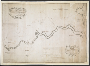
A Copy of the Plan returned by his Maj:tys Com:rs for setling the Boundarys between the Provinces of New Hampshire and the...
45.
A correct map of the coast of New England
46.
A map of the coast of New England, from Staten Island to the island of Breton
47.
A PLAN of the Rivers and Boundary Lines referr'd to in ye Proceedings & Judgment of ye Commissioners for adjusting the Bounds...
48.
A Map Of the River MERRIMACK from the Atlantick Ocean to Pantuckett Falls describing bounds between His Maj:tys Province of New...
49.
A new map of the most considerable plantations of the English in America
50.
A new chart of the coast of New England, Nova Scotia, New France or Canada, with the islands of Newfoundld. Cape Breton St....
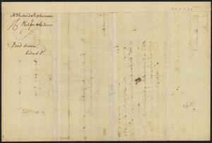
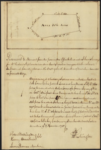
51.
Survey of land for Richard Stephenson in Frederick County; attested by Robert Worthington, Henry Bradshaw and Lewis Thomas : verso
52.
Survey of land for Richard Stephenson in Frederick County; attested by Robert Worthington, Henry Bradshaw and Lewis Thomas : recto
53.
Carte generale du Canada ou Nouvelle France
54.
A map of the most inhabited part of New England : containing the provinces of Massachusets Bay and New Hampshire, with the...
55.
Carte de la Nouvelle Angleterre, Nouvelle Yorck, et Pensilvanie : pour servir à l'Histoire générale des voyages
56.
New Engelland, New York, New Yersey und Pensilvania
57.
Plan des jenigen treffen welches am 8. Sept 1755. zwischen dem Engl. Gen. Johnson, und dem Franz. Gen. Diesckau welcher dabey...
58.
Karte von dem Ostlichen-Stucke von Neu Franckreich oder Canada in America : besonders aber Acadia und Neu Schottland
59.
Carta rappresentante il porto di Boston
60.
A map of the most inhabited part of New England : containing the provinces of Massachusets Bay and New Hampshire, with the...
‹ Prev
Next ›
1
2
3
4
5
6
7