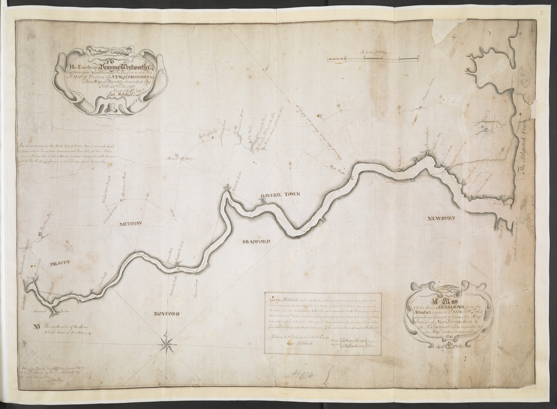
A Map Of the River MERRIMACK from the Atlantick Ocean to Pantuckett Falls describing bounds between His Maj:tys Province of New Hampshire & the Massachusets Bay agreable to His Maj:tys Order in Council 1741
This map is also available in American Revolutionary Geographies Online (ARGO), a collections portal especially built for material relating to the American Revolutionary War Era. Visit ARGO to learn more about this item and explore the historical geography of North America in the late eighteenth century.
Item Information
- Title:
- A Map Of the River MERRIMACK from the Atlantick Ocean to Pantuckett Falls describing bounds between His Maj:tys Province of New Hampshire & the Massachusets Bay agreable to His Maj:tys Order in Council 1741
- Surveyor:
- Mitchell, George, -1755
- Cartographer:
- Mathias, G.
- Dedicatee:
- Wentworth, Benning, 1696-1770
- Witness:
- Odiorne, Jotham, 1703-1751
- Witness:
- Sherburne, Henry
- Former owner:
- Royal United Services Institute for Defence and Security Studies
- Name on Item:
-
George Mitchell makes Oath that this Survey made by him of the River Merrimack from the Mouth of the said River to Pantuckett Falls is true & exact to the best of his Skill & knowledge, & that the Line described in the Plan is as conformable to His Maj:tys Determination in Council as was in his Power to draw, but finding it Impracticable to stick to the Letter of said Determination; has in some places taken from one Province, & made Ample Allowance for the same in the next reach of the River. Portsmouth New Hampshire March 8:th 1741. Geo. Mitchell. Sworn Before Jotham Odiorne H. Sherburne Justices of Peace.
- Date:
-
[1741]
- Format:
-
Maps/Atlases
- Location:
- British Library
- Collection (local):
-
British Library Collection
- Subjects:
-
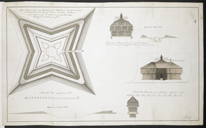
Fortification--Maine--Fort Pownall--Maps, Manuscript--Early works to 1800
Military art and science--Maine--Fort Pownall--Maps, Manuscript--Early works to 1800
New Hampshire--Maps--Early works to 1800
Massachusetts--Maps--Early works to 1800
Merrimack River (N.H. and Mass.)--Maps--Early works to 1800
- Places:
-
Massachusetts
Merrimack River
New Hampshire
Fort Point State Park
- Extent:
- 1 map : manuscript pen and ink ; 51 x 72 cm
- Terms of Use:
-
No known copyright restrictions.
This work is licensed for use under a Creative Commons Attribution Non-Commercial Share Alike License (CC BY-NC-SA).

- Publisher:
-
[Place of production not identified] :
A true Copy from the Original Map transmitted to the Board of Trade by Benning Wentworth Es:r Gov:r of New Hampshire. G. Mathias,
- Scale:
-
Scale not given
- Language:
-
English
- Catalog Record:
-
http://searcharchives.bl.uk/IAMS_VU2:IAMS040-001999743
- Notes:
-
Shows geographical detail along river banks only. Depicts the River Merrimack from the Atlantic Ocean westwards as far as present-day Pawtuckettville.
Shows title in decorative cartouche at lower right.
Shows cartographer's witnessed authorship in a simple surround next to the title.
Shows "true copy" statement at lower left.
Shows dedication in a decorative cartouche at upper left, "TO His Excellency Benning Wentworth Esq.r Captain Gen.l & Commander in Chief in & over His Majesty's Province of NEW HAMPSHIRE: &c This Map is Humbly Inscribed By His Excellency's Most Obed.t Serv.t Geo. Mitchell Surv:r".
Date of production supplied by Boston Public Library.
Copy at Add Ms 57,711.3. Bound in R.U.S.I. Vol LXXVI. Shows manuscript addition of "3" in pencil at upper right. Shows "A 29/53" in pencil at lower left and "No 124" at lower centre. Laid on archival paper and linen. Blue label to verso shows "A 29/53".
- Notes (date):
-
9999
This date is inferred.