Toggle navigation
LMEC Home
Exhibitions
Georeferencing
Tools for Teachers
Collections
My Favorites
Sign Up / Log In
Search
Search the map portal
Map Collection
Map Collection
Map Sets
Search
Search
Search for
Search In
All Fields
Creator
Title
Subject
Place
Search All Digital Collections
Advanced Search
8719 Results
My Search
Start Over
More Like
commonwealth:4m90fk14d
Remove constraint More Like: commonwealth:4m90fk14d
Filter your Search
Place
North and Central America
5,932
United States
4,845
Massachusetts
2,079
Europe
1,396
Suffolk (county)
1,046
Boston
1,019
Canada
449
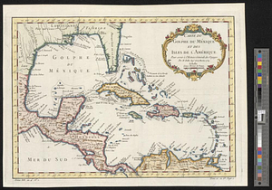
Asia
438
more
Place
»
Topic
Boston (Mass.)--Maps
586
United States--Maps
282
Real property--Massachusetts--Boston--Maps
175
Massachusetts--Maps
162
Landowners--Massachusetts--Boston--Maps
133
North America--Maps--Early works to 1800
103
New England--Maps
102
Europe--Maps
79
more
Topic
»
Date
Date range begin
–
Date range end
Current results range from
1482
to
2023
View distribution
Creator
United States. Hydrographic Office
595
O.H. Bailey & Co
148
Des Barres, Joseph F. W. (Joseph Frederick Wallet), 1722-1824
123
United States. Post Office Dept
120
Ptolemy, 2nd cent
100
Walling, Henry Francis, 1825-1888
94
Geological Survey (U.S.)
86
Jefferys, Thomas, -1771
86
more
Creator
»
Format
Maps/Atlases
8,659
Manuscripts
216
Prints
56
Books
36
Objects/Artifacts
10
Drawings/Illustrations
8
Posters
5
Georeferenced
Yes
872
No
7,847
Collection
Norman B. Leventhal Map & Education Center Collection
8,696
Boston and New England Maps
2,233
Urban Maps
2,023
Maritime Charts and Atlases
1,085
American Revolutionary War-Era Maps
638
Boston Redevelopment Authority Collection
87
Maps from AAS
17
William L. Clements Library Collection
6
more
Collection
»
Available to use
No known restrictions
8,554
Creative Commons license
47
Search Constraints
Sort by relevance
relevance
title
date (asc)
date (desc)
Number of results to display per page
20 per page
10
per page
20
per page
50
per page
100
per page
View results as:
grid view
map view
Search Results
41.
An accurate map of the West Indies
42.
An accurate map of the West Indies, containing the Bahama & Caribbe islands the Great & Little Antilles; with the Leward and...
43.
An accurate map of the West Indies with the adjacent coast of America
44.
An Accurate map of the West Indies with the adjacent coast of America. 1796
45.
Carolinae Floridae nec non insularum Bahamensium : cum partibus adjacendibus delineatio ad Exemplar Londinense in lucem edita a...
46.
Carte du Golphe du Méxique et des isles de l'Amérique : pour servir à l'Histoire générale des voyages
47.
Carte geo-hydrographique du Golfe du Mexique et de ces isles : construit d'après les mémoires les plus recens, et assujeties...
48.
A Correct chart of the West India islands : engraved for Malham's naval gazetteer
49.
Map of North America from 20 to 80 degrees north latitude : exhibiting the recent discoveries, geographical and nautical; drawn...
50.
Map of the European settlements in the West Indies
51.
A new and correct map of the American islands, now called the West Indies, with the whole coast of the neighbouring continent
52.
A new map of the West Indian islands; : as they are possessed by the European powers; drawn from the most recent authorities
53.
Plan of the bay of Tortuga
54.
West Indies
55.
The West Indies, : exhibiting the English French Spanish Dutch & Danish settlements with the adjacent parts of North & South...
56.
West Indies, : with the harbour & fort of Omoa. From the best authorities
57.
The Windward Passage, with the several passages from the east end of Cuba : & from the north part of St. Domingo
58.
The 100th anniversary map of Abraham Lincoln's visit to Massachusetts, September 11-23, 1848
59.
1630 shoreline
60.
1879. Progress map of the U.S. Geographical Surveys west of the 100th Meridian : prepared under the direction of 1st Lieut....
‹ Prev
Next ›
1
2
3
4
5
6
7
…
435
436