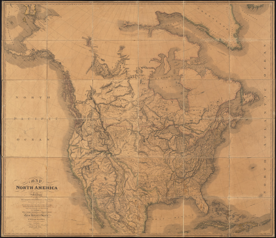
Map of North America from 20 to 80 degrees north latitude : exhibiting the recent discoveries, geographical and nautical; drawn chiefly from the authorities of M. de Humbolt, Lieutt. Pike, Messrs. Lewis and Clarke, Sir Alexr. Mackenzie, Mr. Hearne, Coll. Bouchette, Captn. Vancouver R.N. Capt. Ross R.N. & c. also describing the boundary lines between territories of Great Britain & Spain with the United States
Item Information
- Title:
- Map of North America from 20 to 80 degrees north latitude : exhibiting the recent discoveries, geographical and nautical; drawn chiefly from the authorities of M. de Humbolt, Lieutt. Pike, Messrs. Lewis and Clarke, Sir Alexr. Mackenzie, Mr. Hearne, Coll. Bouchette, Captn. Vancouver R.N. Capt. Ross R.N. & c. also describing the boundary lines between territories of Great Britain & Spain with the United States
- Description:
-
America Transformed: This large wall map integrated topographic and hydrographic detail gained from various European and American explorations of interior North America. It included data from expeditions led by Alexander von Humboldt (northern Mexico), Alexander MacKenzie (Canadian Great Plains), and George Vancouver (Pacific northwest coast), as well as Meriwether Lewis, William Clark, and Zebulon Pike, all of whom were commissioned by President Thomas Jefferson to explore the newly acquired Louisiana Territory. This accumulated knowledge demonstrated that the western part of the continent was not dominated by a single mountain range as was previously hypothesized, but by a complex series of ranges that came to be known as the Rocky Mountains.
This rare map, considered the most accurate representation of North America at the time of its publication, incorporates recent findings from explorations of the American West, Northwest and Canada, and provides an advanced depiction of the geography that would become part of the United States by the mid-nineteenth century. The cartography is derived from the explorations of Pike, Humboldt, Lewis and Clark, Mckenzie, Hearns, Bouchette, Vancouver, Parry and Ross, who ventured into the Northwest Passage, upper Canada, the lower Arctic, the Rocky Mountains and the Sierra Nevadas. The map also incorporates new border settlements with Spain (Mexico) and Britain (Canada).
- Creator:
- Faden, William, 1749-1836
- Date:
-
1820
- Format:
-
Maps/Atlases
- Location:
- Private Collection
- Collection (local):
-
Private Collection
- Subjects:
-
Indians of North America--Maps
Roads--North America--Maps
United States--Boundaries--Great Britain--Maps
Great Britain--Boundaries--United States--Maps
United States--Boundaries--Spain--Maps
Spain--Boundaries--United States--Maps
North America--Maps
West Indies--Maps
- Places:
-
North America (area)
West Indies
- Extent:
- 1 map : color ; 146 x 165 cm
- Terms of Use:
-
No known copyright restrictions.
No known restrictions on use.
- Publisher:
-
London :
W. Faden
- Scale:
-
Scale approximately 1:4,550,000
- Language:
-
English
- Notes:
-
Relief shown by hachures.
Shows areas of Indian habitation, cities, roads, state and territorial boundaries for North America and the West Indies.
Includes notes and dates.
Outline color.
- Notes (exhibitions):
-
Exhibited: "America transformed. Part 1: the United States expands westward," organized by the Norman B. Leventhal Map & Education Center at the Boston Public Library, 2019.
- Identifier:
-
06_01_014224
- Barcode:
-
30000004585093