Toggle navigation
LMEC Home
Exhibitions
Georeferencing
Tools for Teachers
Collections
My Favorites
Sign Up / Log In
Search
Search the map portal
Map Collection
Map Collection
Map Sets
Search
Search
Search for
Search In
All Fields
Creator
Title
Subject
Place
Search All Digital Collections
Advanced Search
8720 Results
My Search
Start Over
More Like
commonwealth:4m90f3383
Remove constraint More Like: commonwealth:4m90f3383
Filter your Search
Place
North and Central America
5,951
United States
4,869
Massachusetts
2,079
Europe
1,396
Suffolk (county)
1,046
Boston
1,019
Canada
449
Asia
438
more
Place
»
Topic
Boston (Mass.)--Maps
586
United States--Maps
282
Real property--Massachusetts--Boston--Maps
175
Massachusetts--Maps
162
Landowners--Massachusetts--Boston--Maps
133
North America--Maps--Early works to 1800
103
New England--Maps
102
Europe--Maps
79
more
Topic
»
Date
Date range begin
–
Date range end
Current results range from
1482
to
2023
View distribution
Creator
United States. Hydrographic Office
595
O.H. Bailey & Co
148
Des Barres, Joseph F. W. (Joseph Frederick Wallet), 1722-1824
123
United States. Post Office Dept
120
Ptolemy, 2nd cent
100
Walling, Henry Francis, 1825-1888
94
Geological Survey (U.S.)
86
Jefferys, Thomas, -1771
85
more
Creator
»
Format
Maps/Atlases
8,660
Manuscripts
216
Prints
56
Books
36
Objects/Artifacts
10
Drawings/Illustrations
8
Posters
5
Georeferenced
Yes
869
No
7,851
Collection
Norman B. Leventhal Map & Education Center Collection
8,694
Boston and New England Maps
2,233
Urban Maps
2,023
Maritime Charts and Atlases
1,083
American Revolutionary War-Era Maps
641
Boston Redevelopment Authority Collection
87
William L. Clements Library Collection
21
New-York Historical Society Collection
3
more
Collection
»
Available to use
No known restrictions
8,555
Creative Commons license
49
Search Constraints
Sort by relevance
relevance
title
date (asc)
date (desc)
Number of results to display per page
20 per page
10
per page
20
per page
50
per page
100
per page
View results as:
grid view
map view
Search Results
61.
A map of the country adjacent to Kingsbridge, surveyed by order of his excellency General Sir Henry Clinton K.B., commander in...
62.
Part of the modern counties of Westchester and Bronx
63.
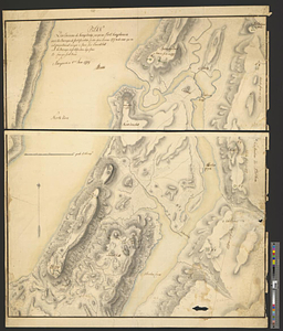
Plan des environs de Kingsbridge jusqu'au Fort Knyphausen avec les ouvrages de fortification faites dans l'année 1779 & de ceux...
64.
Plan des ouvrages faites en front du fort Knyphausen, New Yorck ce 4 me. Novr 1779
65.
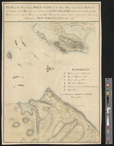
Plan of the narrows of Hell Gate, on the East River near which batteries of cannon, and morters, were erected on Long Island :...
66.
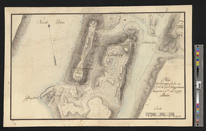
A survey of the defile and that part of York Island adjacent to Fort Knyphausen
67.
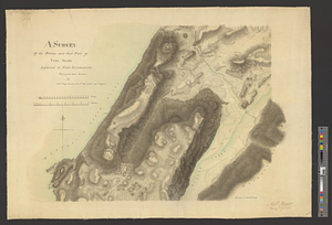
A topographical sketch of the island of New York, with part of the circumjacent country : November 1775
68.
The 100th anniversary map of Abraham Lincoln's visit to Massachusetts, September 11-23, 1848
69.
1630 shoreline
70.
1879. Progress map of the U.S. Geographical Surveys west of the 100th Meridian : prepared under the direction of 1st Lieut....
71.
1903 Map of Salem and surrounding places
72.
19th annual convention of the National Association of Real Estate Boards : at Tulsa, June 7 to June 11 in 1926
73.
2005 significant U.S. hurricane strikes
74.
The 2100 project : an atlas for the Green New Deal
75.
227 Harzgerode
76.
305 Glatz
77.
38,000,000 escaped -- 10,000,000 died
78.
4 Kinten
79.
660 Wakulah St., Roxbury
80.
74 miles on the ocean scenic highway U.S. 1
‹ Prev
Next ›
1
2
3
4
5
6
7
8
…
435
436