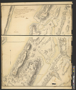
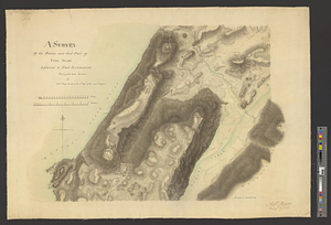
A survey of the defile and that part of York Island adjacent to Fort Knyphausen
This map is also available in American Revolutionary Geographies Online (ARGO), a collections portal especially built for material relating to the American Revolutionary War Era. Visit ARGO to learn more about this item and explore the historical geography of North America in the late eighteenth century.
Item Information
- Title:
- A survey of the defile and that part of York Island adjacent to Fort Knyphausen
- Contributor:
- Mercer, Alexander, engineer
- Creator:
- Sproule, Geo. F. (George F.), 1741-1817
- Name on Item:
-
surveyed and drawn by Lieut. George Sproule of the 16th Regt. of Foot assist. engineer
- Date:
-
November 1778
- Format:
-
Maps/Atlases
- Genre:
-
Manuscript maps
- Location:
- William L. Clements Library
- Collection (local):
-
William L. Clements Library Collection
- Subjects:
-
Fort Washington (New York, N.Y.)--Maps
Manhattan (New York, N.Y.)--Maps
United States--History--Revolution, 1775-1783--Maps
- Places:
-
New YorkNew YorkManhattan
Fort Washington (historical)
- Extent:
- 1 ms. map : col. ; 55.2 x 76.5 cm.
- Terms of Use:
-
The University of Michigan Library provides access to these materials for educational and research purposes. These materials may be under copyright. If you decide to use any of these materials, you are responsible for making your own legal assessment and securing any necessary permission. If you have questions about the collection, please contact the William L. Clements Library.
Contact host institution for more information.
- Scale:
-
Scale 1:4,800.
- Language:
-
English
- Catalog Record:
-
Catalog record
- Notes:
-
Finished, colored, topographical map of the area around the former Fort Washington, captured and renamed by the British in 1776.
Nearby barracks and fortifications are shown.
Endorsed at lower right: Alexr. Mercer, commg engineer.
Clinton Map 151.
- Identifier:
-
8383
- Barcode:
-
B2821930