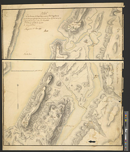
Isle de Newyork : reconnaissance des ouvrages du nord de lisle de Newyork faite en presence des Généraux, Wasington et Rochambeau foutenue par un corps de 5000 hommes détaché de l'armée comninée de France et d'Amérique compée à Philipsburg dont les principaux points ont eté détermines géometriquement le 22 et 23 Juillet 1781

This map is also available in American Revolutionary Geographies Online (ARGO), a collections portal especially built for material relating to the American Revolutionary War Era. Visit ARGO to learn more about this item and explore the historical geography of North America in the late eighteenth century.
Item Information
- Title:
- Isle de Newyork : reconnaissance des ouvrages du nord de lisle de Newyork faite en presence des Généraux, Wasington et Rochambeau foutenue par un corps de 5000 hommes détaché de l'armée comninée de France et d'Amérique compée à Philipsburg dont les principaux points ont eté détermines géometriquement le 22 et 23 Juillet 1781
- Creator:
- Colbert, Edouard Charles Victurnien, Comte de Maulevrier, 1758-1820
- Date:
-
[1781]
- Format:
-
Maps/Atlases
- Genre:
-
Manuscript maps
- Location:
- William L. Clements Library
- Collection (local):
-
William L. Clements Library Collection
- Subjects:
-
Kingsbridge (New York, N.Y.)--Maps
Fort Washington (New York, N.Y.)--Maps
Manhattan (New York, N.Y.)--Maps
United States--History--Revolution, 1775-1783--Maps
- Places:
-
New YorkNew YorkKingsbridge
New YorkNew YorkManhattan
Fort Washington (historical)
- Extent:
- 1 ms. map : col. ; 43.2 x 62.5 cm.
- Terms of Use:
-
The University of Michigan Library provides access to these materials for educational and research purposes. These materials may be under copyright. If you decide to use any of these materials, you are responsible for making your own legal assessment and securing any necessary permission. If you have questions about the collection, please contact the William L. Clements Library.
Contact host institution for more information.
- Scale:
-
Scale of toises.
- Language:
-
French
- Catalog Record:
-
Catalog record
- Notes:
-
Finished, colored, topographical map of northern Manhattan Island and the Kingsbridge-Fort Knyphausen area with a long and detailed table of references identifying and describing the British fortifications there.
Authorship attributed by style.
- Notes (date):
-
This date is inferred.
- Identifier:
-
8684
- Barcode:
-
B2826513