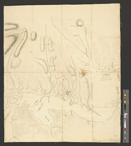
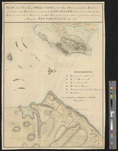
Plan of the narrows of Hell Gate, on the East River near which batteries of cannon, and morters, were erected on Long Island : with a view to take of the defences and make a breach in the rebel fort, on the opposit shore to facilitate a landing of troops on New York Island
This map is also available in American Revolutionary Geographies Online (ARGO), a collections portal especially built for material relating to the American Revolutionary War Era. Visit ARGO to learn more about this item and explore the historical geography of North America in the late eighteenth century.
Item Information
- Title:
- Plan of the narrows of Hell Gate, on the East River near which batteries of cannon, and morters, were erected on Long Island : with a view to take of the defences and make a breach in the rebel fort, on the opposit shore to facilitate a landing of troops on New York Island
- Date:
-
1776
- Format:
-
Maps/Atlases
- Genre:
-
Manuscript maps
- Location:
- William L. Clements Library
- Collection (local):
-
William L. Clements Library Collection
- Subjects:
-
Hell Gate (New York, N.Y.)--Maps
Manhattan (New York, N.Y.)--Maps
United States--History--Revolution, 1775-1783--Maps
- Places:
-
New YorkNew York (county)Hell Gate (channel)
New YorkNew YorkManhattan
- Extent:
- 1 ms. map : col. ; 50 x 35 cm
- Terms of Use:
-
The University of Michigan Library provides access to these materials for educational and research purposes. These materials may be under copyright. If you decide to use any of these materials, you are responsible for making your own legal assessment and securing any necessary permission. If you have questions about the collection, please contact the William L. Clements Library.
Contact host institution for more information.
- Scale:
-
Scale 1:3,200.
- Language:
-
English
- Catalog Record:
-
Catalog record
- Notes:
-
Shows details of fortifications and lines of fire of the guns.
Key of references identifies major features.
Clinton Maps 136.
- Identifier:
-
8360
- Barcode:
-
B1936335