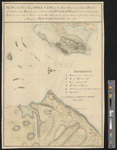
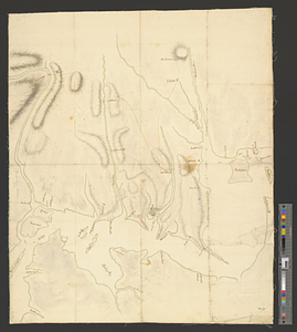
Part of the modern counties of Manhattan, Westchester and Queens
This map is also available in American Revolutionary Geographies Online (ARGO), a collections portal especially built for material relating to the American Revolutionary War Era. Visit ARGO to learn more about this item and explore the historical geography of North America in the late eighteenth century.
Item Information
- Title:
- Part of the modern counties of Manhattan, Westchester and Queens
- Date:
-
[1770–1779]
- Format:
-
Maps/Atlases
- Genre:
-
Manuscript maps
- Location:
- William L. Clements Library
- Collection (local):
-
William L. Clements Library Collection
- Subjects:
-
Westchester County (N.Y.)--Maps
Hell Gate (New York, N.Y.)--Maps
United States--History--Revolution, 1775-1783--Maps
- Places:
-
New YorkWestchester (county)
New YorkNew York (county)Hell Gate (channel)
- Extent:
- 1 ms. map : outline col. ; 61.5 x 50.1 cm.
- Terms of Use:
-
The University of Michigan Library provides access to these materials for educational and research purposes. These materials may be under copyright. If you decide to use any of these materials, you are responsible for making your own legal assessment and securing any necessary permission. If you have questions about the collection, please contact the William L. Clements Library.
Contact host institution for more information.
- Scale:
-
Scale ca. 1:29,520.
- Language:
-
English
- Catalog Record:
-
Catalog record
- Notes:
-
Finished, partly colored, topographical map showing the area, primarily in Westchester County, from Kingsbridge eastward to Hart Island and illustrating the surroundings of Hell Gate and Flushing Bay.
Several roads are indicated in Westchester County, and the names of a few householders are given.
Clinton Map.
- Notes (date):
-
This date is inferred.
- Identifier:
-
8289
- Barcode:
-
B2846412