Toggle navigation
LMEC Home
Exhibitions
Georeferencing
Tools for Teachers
Collections
My Favorites
Sign Up / Log In
Search
Search the map portal
Map Collection
Map Collection
Map Sets
Search
Search
Search for
Search In
All Fields
Creator
Title
Subject
Place
Search All Digital Collections
Advanced Search
28 Results
My Search
Start Over
More Like
commonwealth:dz010v72w
Remove constraint More Like: commonwealth:dz010v72w
Collection
Norman B. Leventhal Map & Education Center Collection
Remove constraint Collection: Norman B. Leventhal Map & Education Center Collection
Filter your Search
Place
Massachusetts
28
North and Central America
28
United States
28
Boston
27
Suffolk (county)
27
Bunker Hill
10
Boston Harbor
5
Charlestown
4
Topic
Boston (Mass.)--History--Revolution, 1775-1783--Maps--Early works to 1800
28
Fortification--Massachusetts--Boston--Maps--Early works to 1800
14
Bunker Hill, Battle of, Boston, Mass., 1775--Maps--Early works to 1800
11
Boston Harbor (Mass.)--Maps--Early works to 1800
5
Boston (Mass.)--Buildings, structures, etc--Maps--Early works to 1800
2
Boston (Mass.)--Maps--Early works to 1800
2
United States--History--Revolution, 1775-1783--Maps--Early works to 1800
2
Boston (Mass.)--History--Siege, 1775-1776--Maps--Early works to 1800
1
more
Topic
»
Date
Date range begin
–
Date range end
Current results range from
1764
to
1797
1764 : 1798
1764
1798
View distribution
Creator
Page, Thomas Hyde, Sir, 1746-1821
9
Beaurain, Jean de, 1696-1771
4
Faden, William, 1749-1836
3
Aitken, Robert, 1735-1802
2
Montrésor, John, 1736-1799
2
Montrésor, John, 1736-1799
2
Pelham, Henry, 1749-1806
2
Stedman, C. (Charles), 1753-1812
2
more
Creator
»
Format
Maps/Atlases
28
Georeferenced
Yes
3
No
25
Collection
Norman B. Leventhal Map & Education Center Collection
[remove]
28
American Revolutionary War-Era Maps
27
Boston and New England Maps
27
Mapping Boston Collection
16
Urban Maps
7
Available to use
Creative Commons license
15
No known restrictions
13
Search Constraints
Sort by relevance
relevance
title
date (asc)
date (desc)
Number of results to display per page
20 per page
10
per page
20
per page
50
per page
100
per page
View results as:
grid view
map view
Search Results
1.
An accurate map of the country round Boston in New England from the best authorities
2.
Boston et ses environs
3.
Boston, its environs and harbour, with the rebels works raised against that town in 1775
4.
Boston with its environs
5.
Carte du port et havre de Boston avec les côtes adjacentes, dans laquel on a tracée les camps et les retranchemens occupé,...
6.
Carte du port et havre de Boston avec les côtes adjacentes, dans laquel on a tracée les camps et les retranchemens occupé,...
7.
Carte von dem Hafen und der Stadt Boston : mit den umliegenden Gegenden und der Lägern sowohl der Americaner als auch des...
8.
Carte von dem Hafen und der Stadt Boston : mit den umliegenden Gegenden und der Lägern sowohl der Americaner als auch des...
9.
Exact plan of General Gage's lines on Boston Neck in America
10.
Map of the environs of Boston
11.
A new and correct plan of the town of Boston
12.
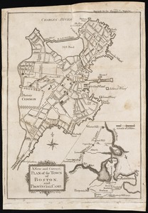
A new and correct plan of the town of Boston, and provincial camp
13.
Plan de la ville et du port de Boston : capitale de la Nouvelle Angleterre : erigée prémierement en 1630, et en 1735 elle fut...
14.
A plan of Boston, and its environs : shewing the true situation of His Majesty's army, and also those of the rebels
15.
A plan of Boston in New England with its environs : including Milton, Dorchester, Roxbury, Brooklin, Cambridge, Medford,...
16.
A plan of Boston in New England with its environs : including Milton, Dorchester, Roxbury, Brooklin, Cambridge, Medford,...
17.
A plan of the action at Breeds Hill, on the 17th of June 1775 : between the American forces and the British troops :...
18.
A plan of the action at Bunkers Hill, on the 17th. of June, 1775 : between His Majesty's troops under the command of Major...
19.
A plan of the action at Bunkers Hill, on the 17th. of June, 1775 : between His Majesty's troops under the command of Major...
20.
A plan of the action at Bunkers Hill on the 17th of June 1775 between His Majesty's troops, under the command of Major General...
+
-
Redo search here
Search when I move the map
Leaflet
| ©
OpenStreetMap
contributors, ©
CartoDB
‹ Prev
Next ›
1
2