Toggle navigation
LMEC Home
Exhibitions
Georeferencing
Tools for Teachers
Collections
My Favorites
Sign Up / Log In
Search
Search the map portal
Map Collection
Map Collection
Map Sets
Search
Search
Search for
Search In
All Fields
Creator
Title
Subject
Place
Search All Digital Collections
Advanced Search
13385 Results
Filter your Search
Place
North and Central America
10,111
United States
8,249
Massachusetts
2,691
Suffolk (county)
1,664
Boston
1,621
Europe
1,386
Canada
949
New York
640
more
Place
»
Topic
Boston (Mass.)--Maps
741
City planning--Massachusetts--Boston--Maps
418
United States--History--Revolution, 1775-1783--Maps
329
United States--Maps
315
Urban renewal--Massachusetts--Boston--Maps
254
Real property--Massachusetts--Boston--Maps
252
Massachusetts--Maps
219
Insurance surveys
197
more
Topic
»
Date
Date range begin
–
Date range end
Current results range from
1482
to
2023
View distribution
Creator
United States. Hydrographic Office
595
Boston Redevelopment Authority
403
Des Barres, Joseph F. W. (Joseph Frederick Wallet), 1722-1824
247
Royal United Services Institute for Defence and Security Studies
160
Jefferys, Thomas, -1771
154
George, III, King of Great Britain, 1738-1820
152
George, IV, King of Great Britain, 1762-1830
151
O.H. Bailey & Co
148
more
Creator
»
Format
Maps/Atlases
13,205
Manuscripts
985
Prints
102
Books
49
Drawings/Illustrations
44
Photographs
15
Objects/Artifacts
13
Documents
7
more
Format
»
Georeferenced
Yes
979
No
12,406
Collection
Norman B. Leventhal Map & Education Center Collection
8,891
American Revolutionary War-Era Maps
3,305
Boston and New England Maps
2,804
Urban Maps
2,397
Maritime Charts and Atlases
1,150
William L. Clements Library Collection
910
Library of Congress Collection
618
Boston Redevelopment Authority Collection
475
more
Collection
»
Available to use
No known restrictions
9,952
Creative Commons license
1,677
Search Constraints
Sort by relevance
relevance
title
date (asc)
date (desc)
Number of results to display per page
100 per page
10
per page
20
per page
50
per page
100
per page
View results as:
grid view
map view
Search Results
701.
Atlas of the county of Suffolk, Massachusetts : vol. 3rd including Boston and Dorchester : from actual surveys and official...
702.
Atlas of the county of Suffolk, Massachusetts : vol. 4th including East Boston, city of Chelsea, Revere and Winthrop : from...
703.
Atlas of the county of Suffolk, Massachusetts : vol. 5th, West Roxbury, now ward 17, Boston : from actual survey & official...
704.
Atlas of the county of Suffolk, Massachusetts : vol. 6th including the late city of Charlestown, now wards 20,21 and 22, city...
705.
Atlas of the county of Suffolk, Massachusetts, vol. 1 : including Boston proper
706.
Atlas of the county of Suffolk, Massachusetts, vol. 2 : late city of Roxbury, now wards 13-14 and 15, city of Boston
707.
Atlas of the county of Suffolk, Massachusetts, vol. 3 : including South Boston and Dorchester
708.
Atlas of the county of Suffolk, Massachusetts, vol. 4 : including East Boston, city of Chelsea, Revere and Winthrop
709.
Atlas of the county of Suffolk, Massachusetts, vol. 5 : West Roxbury, now ward 17, Boston
710.
Atlas of the county of Suffolk, Massachusetts, vol. 6 : including the late city of Charlestown, now wards 20, 21, 22 City of...
711.
Atlas of the county of Suffolk, Massachusetts, vol. 7 : late town of Brighton, now ward 19 of Boston, Massachusetts
712.
Atlas of the North Shore : Beverly to Magnolia, Essex Co. Mass. : from official plans and records and actual surveys
713.
Atlas of the North Shore, Beverly to Magnolia, Essex Co., Massachusetts
714.
Atlas of the town of Beverly, Massachusetts
715.
Atlas of the town of Beverly, Massachusetts : from official records, private plans and actual surveys
716.
Atlas of the town of Brookline 1969
717.
Atlas of the town of Brookline 1972
718.
Atlas of the town of Brookline, Massachusetts : from official records, private plans and actual surveys
719.
Atlas of the town of Brookline, Massachusetts : from actual surveys & official records
720.
Atlas of the town of Brookline, Norfolk County, Massachusetts
721.
Atlas of the town of Brookline, Norfolk County, Massachusetts
722.
Atlas of the town of Brookline, Norfolk County, Massachusetts
723.
Atlas of the town of Brookline, Norfolk County, Massachusetts
724.
Atlas of the town of Brookline, Norfolk County, Massachusetts : from actual surveys and official plans
725.
Atlas of the town of Brookline, Norfolk County, Massachusetts : from actual surveys and official plans
726.
Atlas of the town of Brookline, Norfolk County, Massachusetts : from actual surveys and official plans
727.
Atlas of the town of Brookline, Norfolk County, Massachusetts : from actual surveys and official plans
728.
Atlas of the town of Brookline, Norfolk County, Massachusetts : from actual surveys and official plans
729.
Atlas of the town of Brookline, Norfolk County, Massachusetts : from actual surveys and official plans
730.
Atlas of the town of Brookline, Norfolk County, Massachusetts : from actual surveys and official plans
731.
Atlas of the town of Hull, Plymouth County, and part of the Jerusalem Road, Norfolk County, Massachussetts, from actual surveys...
732.
Atlas of the town of Leominster, Worcester County, Massachusetts
733.
Atlas of the town of Marblehead, Massachusetts : based on plans in the office of the Board of Assessors
734.
Atlas of the town of Marblehead, Massachusetts : based on plans in the office of the Board of Assessors
735.
Atlas of the town of Melrose, Middlesex County, Massachusetts
736.
Atlas of the town of Milton Norfolk County Mass. : from official plans and private surveys
737.
Atlas of the town of Milton, Norfolk County, Massachusetts
738.
Atlas of the town of Milton, Norfolk County, Massachusetts
739.
Atlas of the town of Milton Norfolk County, Massachusetts
740.
Atlas of the town of Nahant, Essex County, Mass.
741.
Atlas of the town of Nahant, Massachusetts
742.
Atlas of the town of Swampscott, Essex County, Mass. : from official plans and actual surveys
743.
Atlas of the town of Swampscott, Essex County, Mass. : from official plans and actual surveys
744.
Atlas of the town of Swampscott, Massachusetts
745.
Atlas of the town of Wayland
746.
Atlas of the town of Wellesley, Norfolk County, Mass. : from official plans and actual surveys
747.
Atlas of the town of Woburn, Massachusetts
748.
Atlas of the towns of Braintree and Weymouth, Norfolk County, Massachusetts
749.
Atlas of the towns of Braintree and Weymouth, Norfolk County, Massachusetts : from official plans and actual surveys
750.
Atlas of the towns of Needham, Dover, Westwood, Millis and Medfield, Norfolk county, Massachusetts
751.
Atlas of the towns of Needham, Dover, Westwood, Millis and Medfield, Norfolk County, Massachusetts : from official plans and...
752.
Atlas of the towns of North Adams, Adams, Williamstown and Cheshire, Berkshire County, Massachusetts
753.
Atlas of the towns of Revere and Winthrop, Suffolk County, Massachusetts
754.
Atlas of the towns of Topsfield, Ipswich, Essex, Hamilton and Wenham, Essex County, Massachusetts
755.
Atlas of the towns of Topsfield, Ipswich, Essex, Hamilton and Wenham, Essex County, Massachusetts : from official plans and...
756.
Atlas of the towns of Watertown, Belmont, Arlington and Lexington, Middlesex County, Mass. : from official plans and actual...
757.
Atlas of Town of Weymouth, Massachusetts
758.
Atlas of town of Weymouth Massachusetts
759.
Atlas of town of Weymouth Massachusetts
760.
Atlas of town of Weymouth Massachusetts
761.
Atlas of Westfield town, Massachusetts
762.
Atlas of Westfield town, Massachusetts
763.
Atlas of Winchendon town, Massachusetts
764.
Atlas of Worcester County, Massachusetts
765.
Atlas of Worcester county, Massachusetts : from actual surveys
766.
Atlas to Marshall's life of Washington
767.
Atlas town of Wellesley
768.
Atrebates : Evesché d'Arras comté d'Artois subdivisé en toutes ses Iurisdictions scav. gouvernance d'Arras, com.te de St Pol...
769.
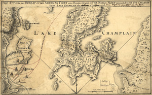
The Attack and defeat of the American fleet under Benedict Arnold : by the King's fleet commanded by Sir Guy Carleton upon Lake...
770.
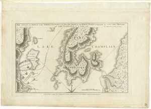
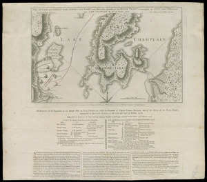
The attack and defeat of the American fleet under Benedict Arnold, by the King's fleet commanded by Capt. Thos. Pringle, upon...
771.
The attack and defeat of the American fleet under Benedict Arnold, by the King's fleet commanded by Capt. Thos. Pringle, upon...
772.
The Attack and defeat of the American fleet under Benedict Arnold, by the Kings fleet commanded by Captn. Thos. Pringle, upon...
773.
The attack and defeat of the American fleet under Benedict Arnold, by the kings fleet commanded by Captn. Thos. Pringle, upon...
774.
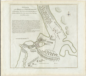
Attack of the rebels upon Fort Penobscot in the province of New England in which their fleet was totally destroyed and their...
775.
Attack of the rebels upon Fort Penobscot in the province of New England in which their fleet was totally destroyed and their...
776.
Attack of the rebels upon Fort Penobscot in the province of New England in which their fleet was totally destroyed and their...
777.
The attack on Bunker Hill in the peninsula of Charlestown the 17th of June 1775
778.
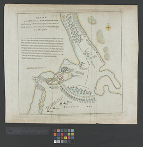
Attacks upon Rhode Island, Augt. 1778
779.
Attaque de la ville d'York en Virginie prise le 19 8bre 1781 par les armées combinées de France et d'Amérique
780.
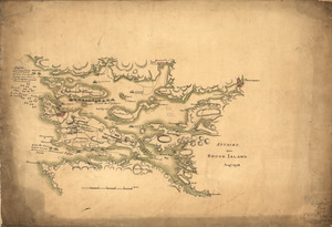
Attaque de l'armée des provinciaux dans Long Island du 27. Aoust 1776 : dessin de l'isle de New-York et des Etats
781.
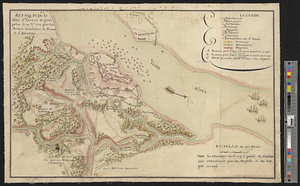
Attaques des forts de Chouaguen en Amérique pris par les français commandés par le Marquis de Montcalm le 14 Août 1756
782.
Attaques des retranchemens devant le fort Carillon en Amérique par les anglais commandés par le général Abercrombie contre les...
783.
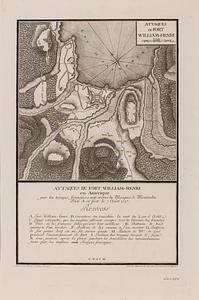
Attaques du fort William-Henri en Amérique par les troupes français aux ordres du Marquis de Montcalm prise de ce fort le 7...
784.
Attawaugan Company "Attawaugan Mill" (Cotton Mill), Killingly, Conn. [insurance map]
785.
The attempt made by the rebels upon Staten Island January 15th 1780
786.
Auburn, Rhode Island : 1890
787.
Die aufnahmen der Engländer, Franzosen und Russen in hinter-Asien bis zum jahre 1858
788.
Ausicht von Boston : nach der natur aufgenommen
789.
Australien und Polynesien
790.
Austria archiducatus
791.
Austria Hungary
792.
Austria Hungary
793.
Austriae archiducatus pars inferior in omnes ejusdem quadrantes ditiones accuratissime et distincte delineata
794.
Austriae archiducatus pars superior in omnes ejusdem quadrantes ditiones accuratissime et distincte delineata
795.
Austria-Hungary
796.
The Austrian French and Dutch Netherlands, from the best authorities
797.
Austria-Russian operations, European war
798.
An authentic plan of the River St. Laurence, from Sillery to the Fall of Montmerenci : with the operations of the Siege of...
799.
An authentic plan of the River St. Laurence, from Sillery to the Fall of Montmorenci : with the operations of the Siege of...
800.
An authentic plan of the River St. Laurence from Sillery to the fall of Montmorenci, with the operations of the siege of Quebec...
‹ Prev
Next ›
1
2
…
4
5
6
7
8
9
10
11
12
…
133
134


![Attawaugan Company "Attawaugan Mill" (Cotton Mill), Killingly, Conn. [insurance map]](https://bpldcassets.blob.core.windows.net/derivatives/images/commonwealth:2r36vc15x/image_thumbnail_300.jpg)