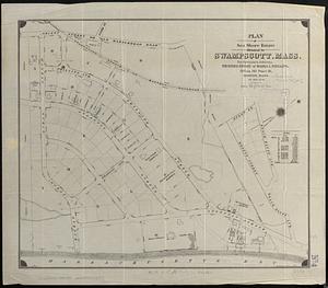
Atlas of the town of Swampscott, Essex County, Mass. : from official plans and actual surveys

Item Information
- Title:
- Atlas of the town of Swampscott, Essex County, Mass. : from official plans and actual surveys
- Publisher:
- Geo. W. Stadly & Co.
- Date:
-
1897
- Format:
-
Maps/Atlases
- Location:
-
Boston Public Library
Norman B. Leventhal Map & Education Center - Collection (local):
-
Norman B. Leventhal Map & Education Center Collection
- Subjects:
-
Swampscott (Mass.)--Maps
Real property--Massachusetts--Swampscott--Maps
Landowners--Massachusetts--Swampscott--Maps
- Places:
-
MassachusettsEssex (county)Swampscott
- Extent:
- 1 atlas (4 preliminary pages, 1 unnumbered, 12 double leaves of plates) : color maps ; 53 cm
- Terms of Use:
-
No known copyright restrictions.
No known restrictions on use.
- Publisher:
-
Boston :
Geo. W. Stadly & Co.
- Language:
-
English
- Notes:
-
Relief not shown.
Hand-colored cadastral maps.
Contains 13 maps on double plates.
Includes "Index to streets and prominent points" and an index map of Swampscott, Mass.
Maps show stone, brick, and frame buildings; stables; green houses; and water pipes & hydrants.
- Identifier:
-
06_01_018535
- Call #:
-
G1234.S9 G46 1897
- Barcode:
-
39999065704221