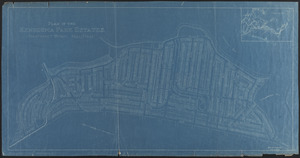
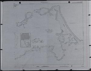
Atlas of the town of Hull, Plymouth County, and part of the Jerusalem Road, Norfolk County, Massachussetts, from actual surveys and official plans

Item Information
- Title:
- Atlas of the town of Hull, Plymouth County, and part of the Jerusalem Road, Norfolk County, Massachussetts, from actual surveys and official plans
- Publisher:
- Geo. H. Walker & Co.
- Date:
-
1895
- Format:
-
Maps/Atlases
Books
- Location:
-
Boston Public Library
Norman B. Leventhal Map & Education Center - Collection (local):
-
Norman B. Leventhal Map & Education Center Collection
- Subjects:
-
Hull (Mass.)--Maps
Real property--Massachusetts--Hull--Maps
Landowners--Massachusetts--Hull--Maps
- Places:
-
MassachusettsPlymouth (county)Hull
- Extent:
- 1 atlas (2 unnumbered leaves, 16 [that is 32] leaves : color maps ; 51 cm
- Terms of Use:
-
No known copyright restrictions.
No known restrictions on use.
- Publisher:
-
Boston :
Geo. H. Walker & Co.
- Scale:
-
Scales differ
- Language:
-
English
- Identifier:
-
06_01_018447
- Call #:
-
G1234.H84 G4 1895
- Barcode:
-
39999065704239