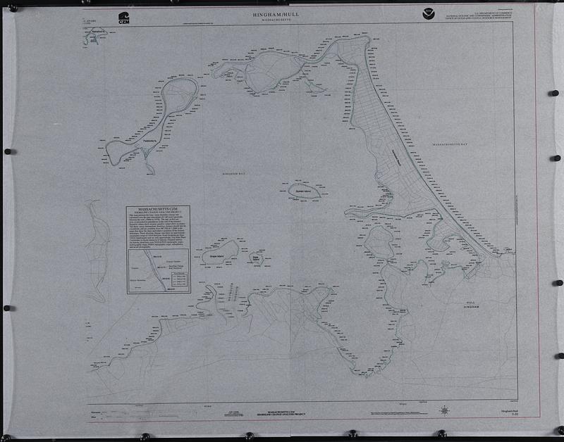
Hingham/Hull Massachusetts : Massachusetts CZM shoreline change analysis project
Item Information
- Title:
- Hingham/Hull Massachusetts : Massachusetts CZM shoreline change analysis project
- Publisher:
- Massachusetts Coastal Zone Management Office
- Cartographer:
- Applied Geographics, Inc.
- Contributor:
- United States. Office of Ocean and Coastal Resource Management
- Name on Item:
-
map production and analysis by Applied Geographics, Inc. under contract to and with technical supervision by Massachusetts Coastal Zone Management
- Date:
-
[ca. 1997]
- Format:
-
Maps/Atlases
- Genre:
-
Outline maps
- Location:
-
Boston Public Library
Norman B. Leventhal Map & Education Center - Collection (local):
-
Applied Geographics, Inc. Records
- Subjects:
-
Hingham (Mass.)--Maps
Hull (Mass.)--Maps
Weymouth (Mass.)--Maps
Coast changes--Massachusetts--Hingham--Maps
Coast changes--Massachusetts--Hull--Maps
Coast changes--Massachusetts--Weymouth--Maps
Shorelines--Massachusetts--Hingham--Maps
Shorelines--Massachusetts--Hull--Maps
Shorelines--Massachusetts--Weymouth--Maps
- Places:
-
MassachusettsPlymouth (county)Hingham
MassachusettsPlymouth (county)Hull
- Extent:
- 1 map : color, plastic ; 80 x 92 cm, on sheet 92 x 117 cm
- Terms of Use:
-
No known copyright restrictions.
No known restrictions on use.
- Publisher:
-
[Boston] :
CZM
- Scale:
-
Scale 1:10,000
- Language:
-
English
- Notes:
-
Outline map on transparent mylar sheet.
Shows historic shoreline during 4 time periods, transects, transect numbers and shoreline change rate.
Includes text about Massachusetts CZM shoreline change analysis project.
Left portion of map not printed on sheet.
"C-20."
"Published for Commonwealth of Massachusetts, Executive Office of Environmental Affairs, Coastal Zone Management Office (CZM)."
"Funding provided by the U.S. Department of Commerce, National Oceanic and Atmospheric Administration, Office of Ocean and Coastal Resource Management."
- Identifier:
-
06_01_018902
- Call #:
-
AppGeo Folder 1 no. 13
- Barcode:
-
30000008056335