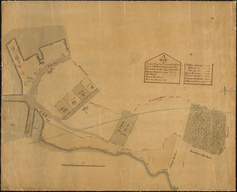
A map of a piece of land and wharf and the buildings thereon of Mr. Samuel Sprague's and Jotham Lincoln Esq. and others lying at Cobbs Hill in Hingham the upland contaning 12 acres, 0 r. 20 rods
Item Information
- Title:
- A map of a piece of land and wharf and the buildings thereon of Mr. Samuel Sprague's and Jotham Lincoln Esq. and others lying at Cobbs Hill in Hingham the upland contaning 12 acres, 0 r. 20 rods
- Date:
-
1834
- Format:
-
Maps/Atlases
- Genre:
-
Manuscript maps
- Location:
-
Boston Public Library
Norman B. Leventhal Map & Education Center - Collection (local):
-
Norman B. Leventhal Map & Education Center Collection
- Subjects:
-
Hingham (Mass.)--Maps
Landowners--Massachusetts--Hingham--Maps
Real property--Massachusetts--Hingham--Maps
- Places:
-
MassachusettsPlymouth (county)Hingham
- Extent:
- 1 manuscript map : hand colored ; 58 x 71 cm
- Terms of Use:
-
No known copyright restrictions.
No known restrictions on use.
- Place of origin:
-
[Hingham, Massachusetts]
- Scale:
-
Scale 1:792. Four rods to an inch
- Language:
-
English
- Notes:
-
Manuscript land survey.
Includes illustrations of houses and buildings.
"Surveyed December 1834."
Includes list of landowners' lots and sizes.
- Identifier:
-
06_01_016971
- Call #:
-
G3764.H6G46 1834 .M37
- Barcode:
-
39999085953063