Toggle navigation
LMEC Home
Exhibitions
Georeferencing
Tools for Teachers
Collections
My Favorites
Sign Up / Log In
Search
Search the map portal
Map Collection
Map Collection
Map Sets
Search
Search
Search for
Search In
All Fields
Creator
Title
Subject
Place
Search All Digital Collections
Advanced Search
50 Results
My Search
Start Over
bahamas
Remove constraint bahamas
Filter your Search
Place
Bahamas
28
North and Central America
28
West Indies
11
Cuba
10
Florida
8
New Providence
7
United States
7
Great Bahama Bank
6
more
Place
»
Topic
Bahamas--Maps
9
West Indies--Maps--Early works to 1800
7
Bahamas--Maps--Early works to 1800
5
Great Bahama Bank (Bahamas)--Maps
5
West Indies--Maps
5
Cuba--Maps
4
Nautical charts--Bahamas
4
Nautical charts--Bahamas--Great Bahama Bank
4
more
Topic
»
Date
Date range begin
–
Date range end
Current results range from
1684
to
1994
View distribution
Creator
United States. Hydrographic Office
18
Barnett, E. (Edward), 1799-1879
4
Jefferys, Thomas, -1771
4
Owen, Richard (Navy Commander)
4
Evans, H. C. (Henry C.)
3
Sefton, W. P. (William P.)
3
Smith, T.
3
Bowen, Emanuel, d. 1767
2
more
Creator
»
Format
Maps/Atlases
50
Manuscripts
3
Georeferenced
Yes
4
No
46
Collection
Norman B. Leventhal Map Center Collection
38
Maritime Charts and Atlases
25
American Revolutionary War-Era Maps
19
American Antiquarian Society Collection
5
Richard H. Brown Revolutionary War Map Collection at Mount Vernon
2
William L. Clements Library Collection
2
Library of Congress Collection
1
Newberry Library Collection
1
more
Collection
»
Available to use
No known restrictions
38
Creative Commons license
3
Search Constraints
Sort by title
relevance
title
date (asc)
date (desc)
Number of results to display per page
20 per page
10
per page
20
per page
50
per page
100
per page
View results as:
grid view
map view
Search Results
1.
An accurate map of the West Indies, : containing the Bahama & Carribe islands, the Great & Little Antilles, with the Leward and...
2.
An accurate map of the West Indies, containing the Bahama & Caribbe islands the Great & Little Antilles; with the Leward and...
3.
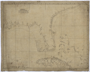
Bahama Islands, Crooked Island Anchorage : from a British survey in 1834
4.
Carolinae Floridae nec non insularum Bahamensium : cum partibus adjacendibus delineatio ad Exemplar Londinense in lucem edita a...
5.
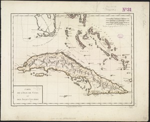
Carte de l'Isle de Cuba et des Isles Lucayes
6.
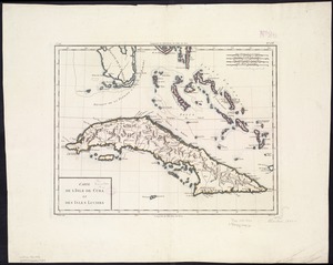
Carte de l'Isle de Cuba et des Isles Lucayes
7.
Carte du Cap Franc̨ois de Saint Domingue, de l'isle de Cuba, de la Jamaique avec le canal de Bahama, l'entrée du fleuve St....
8.
Coast of North America from Point Judith to St. Antonio, (island of Cuba) including the Bahama Banks
9.
Descripcion de la costa de Tierra Firme desde el Rio de la Empalizada hasta Cavo de Clara : Por las latitudes y longitudes de...
10.
The English pilot. The fourth book. Describing the West-India navigation, from Hudson's-Bay to the River Amazones. Particulary...
11.
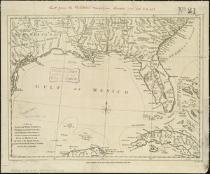
Florida from the latest authorities
12.
Les grandes et petites isles Antilles, et les isles Lucayes avec une partie de la mer du Nord
13.
The Great Bahama Bank from Great Exuma Id. to New Providence Id.
14.
The Great Bahama Bank, from Great Isaac to 23°40' N latitude
15.
The Great Bahama Bank, from Old Bahama Channel to Exuma
16.
The Great Bahama Bank with its islands cays and channels
17.
Hydro-geographical map representing part of Sandwich Gulf, and of the New Bahama Channel, the northernmost extent of the Martir...
18.
The island of Bermudos divided into its tribes, with the castles, forts &c
19.
A map of East and West Florida, Georgia, and Louisiana, with the islands of Cuba, Bahama, and the countries surrounding the...
20.
A map of the British Empire in America with the French and Spanish settlements adjacent thereto
‹ Prev
Next ›
1
2
3