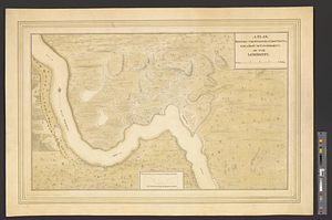
Hydro-geographical map representing part of Sandwich Gulf, and of the New Bahama Channel, the northernmost extent of the Martir Reefs; Dartmouth and Heppel inlets, as also part of the main westward of Cape Florida, on which main is laid out the right honourable the Earl of Dartmouth, his territory ... : from the actual surveys and observations of
This map is also available in American Revolutionary Geographies Online (ARGO), a collections portal especially built for material relating to the American Revolutionary War Era. Visit ARGO to learn more about this item and explore the historical geography of North America in the late eighteenth century.
Item Information
- Title:
- Hydro-geographical map representing part of Sandwich Gulf, and of the New Bahama Channel, the northernmost extent of the Martir Reefs; Dartmouth and Heppel inlets, as also part of the main westward of Cape Florida, on which main is laid out the right honourable the Earl of Dartmouth, his territory ... : from the actual surveys and observations of
- Title (alt.):
-
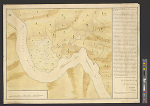
Plan representing four quarters of the town proposed at Cape Florida containing 100 acres
- Creator:
- De Brahm, John Gerar William, 1717-approximately 1799
- Name on Item:
-
William Gerrard de Brahm esqr.
- Date:
-
[1773]
- Format:
-
Maps/Atlases
- Genre:
-
Manuscript maps
- Location:
- William L. Clements Library
- Collection (local):
-
William L. Clements Library Collection
- Subjects:
-
Biscayne Bay (Fla.)--Maps
Miami (Fla.)--Maps
Dartmouth, William Legge, Earl of, 1731-1801
- Places:
-
FloridaMiami-Dade (county)Biscayne Bay
FloridaMiami-Dade (county)Miami
- Extent:
- 1 ms. map ; 48.5 x 59.8 cm.
- Terms of Use:
-
The University of Michigan Library provides access to these materials for educational and research purposes. These materials may be under copyright. If you decide to use any of these materials, you are responsible for making your own legal assessment and securing any necessary permission. If you have questions about the collection, please contact the William L. Clements Library.
Contact host institution for more information.
- Scale:
-
Scale ca. 1:792,000.
- Language:
-
English
- Catalog Record:
-
Catalog record
- Notes:
-
Shows soundings and topographical features of marshes, reefs, swamps, and islands of Biscayne Bay.
Inset shows proposed plan of a town with notations concerning its plan.
Boundaries of Earl of Dartmouth's land shown on the map.
- Notes (date):
-
This date is inferred.
- Identifier:
-
8332
- Barcode:
-
B2495356