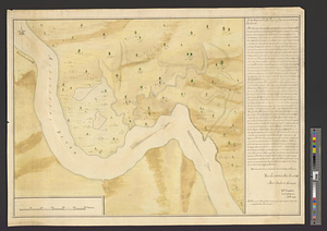
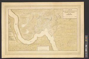
A plan shewing the situation & construction for a seat of government on the Mississippi
This map is also available in American Revolutionary Geographies Online (ARGO), a collections portal especially built for material relating to the American Revolutionary War Era. Visit ARGO to learn more about this item and explore the historical geography of North America in the late eighteenth century.
Item Information
- Title:
- A plan shewing the situation & construction for a seat of government on the Mississippi
- Title (alt.):
-
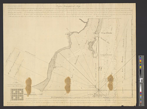
This shews the construction on the side of each gate
- Creator:
- Campbell, John
- Date:
-
[1774]
- Format:
-
Maps/Atlases
- Genre:
-
Manuscript maps
- Location:
- William L. Clements Library
- Collection (local):
-
William L. Clements Library Collection
- Subjects:
-
Dartmouth (La.)--Maps
Saint Francisville (La.)--Maps
Dartmouth, William Legge, Earl of, 1731-1801
- Places:
-
LouisianaWest Feliciana (county)Saint Francisville
- Extent:
- 1 ms. map : col. ; 49.6 x 68 cm.
- Terms of Use:
-
The University of Michigan Library provides access to these materials for educational and research purposes. These materials may be under copyright. If you decide to use any of these materials, you are responsible for making your own legal assessment and securing any necessary permission. If you have questions about the collection, please contact the William L. Clements Library.
Contact host institution for more information.
- Scale:
-
Scale ca. 1:15,840. Scale of inset 1:2,880.
- Language:
-
English
- Catalog Record:
-
Catalog record
- Notes:
-
Finished, colored, topographical map marking the site of the proposed town of Dartmouth on the Mississippi and opposite Point Coupée.
Map includes the town plan and an inset showing the fortifications designed for each of its gates.
Map was possibly sent to Lord Dartmouth.
- Notes (date):
-
This date is inferred.
- Identifier:
-
902
- Barcode:
-
B3316010