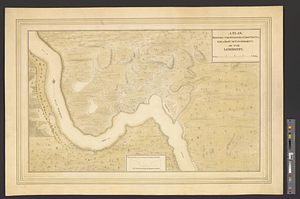
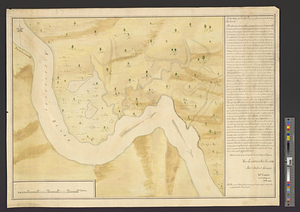
The proposed town of Dartmouth on the Mississippi River
This map is also available in American Revolutionary Geographies Online (ARGO), a collections portal especially built for material relating to the American Revolutionary War Era. Visit ARGO to learn more about this item and explore the historical geography of North America in the late eighteenth century.
Item Information
- Title:
- The proposed town of Dartmouth on the Mississippi River
- Creator:
- Campbell, John
- Name on Item:
-
Ino. Cambel, lieut. of engineers, A.D. 1774
- Date:
-
1774
- Format:
-
Maps/Atlases
- Genre:
-
Manuscript maps
- Location:
- William L. Clements Library
- Collection (local):
-
William L. Clements Library Collection
- Subjects:
-
Dartmouth (La.)--Maps
Saint Francisville (La.)--Maps
Dartmouth, William Legge, Earl of, 1731-1801
- Places:
-
LouisianaWest Feliciana (county)Saint Francisville
- Extent:
- 1 ms. map : col. ; 49.2 x 67.8 cm.
- Terms of Use:
-
The University of Michigan Library provides access to these materials for educational and research purposes. These materials may be under copyright. If you decide to use any of these materials, you are responsible for making your own legal assessment and securing any necessary permission. If you have questions about the collection, please contact the William L. Clements Library.
Contact host institution for more information.
- Scale:
-
Scale ca. 1:15,840.
- Language:
-
English
- Catalog Record:
-
Catalog record
- Notes:
-
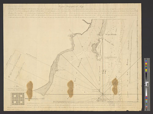
Finished, colored, topographical map marking the site of the proposed town of Dartmouth on the Mississippi and opposite Point Coupée.
Block of text at right is long note from Cambel to Dartmouth extolling the virtues of the site and recommending settlement.
Note below author's signature states: The propos'd town of Dartmouth, is 9 leagues above the Iberville and 3, below Point Coupé.
- Identifier:
-
901
- Barcode:
-
B3315835