Toggle navigation
LMEC Home
Exhibitions
Georeferencing
Tools for Teachers
Collections
My Favorites
Sign Up / Log In
Search
Search the map portal
Map Collection
Map Collection
Map Sets
Search
Search
Search for
Search In
All Fields
Creator
Title
Subject
Place
Search All Digital Collections
Advanced Search
111 Results
My Search
Start Over
Date
1845
Remove constraint Date: <span class='single'>1845</span>
Filter your Search
Place
North and Central America
46
United States
37
Oceania
32
Europe
15
Massachusetts
13
French Polynesia
9
Fiji
8
Germany
6
more
Place
»
Topic
United States Exploring Expedition (1838-1842)
16
Tuamotu Archipelago (French Polynesia)--Maps
6
China--Maps
5
Boston (Mass.)--Maps
4
Korea--Maps
4
Massachusetts--Maps
4
Europe, Central--Maps
3
Germany--Maps
3
more
Topic
»
Date
1845
[remove]
111
Date range begin
–
Date range end
Current results range from
1770
to
1990
1845
to
1845
111
Creator
United States Exploring Expedition (1838-1842)
34
Wilkes, Charles, 1798-1877
31
Sherman & Smith
19
Boynton, George W., -1884
3
Knight, J. (Engraver)
3
Bache, A. D. (Alexander Dallas), 1806-1867
2
Collinson, Richard, Sir, 1811-1883
2
Hassler, F. R. (Ferdinand Rudolph), 1770-1843
2
more
Creator
»
Format
Maps/Atlases
111
Manuscripts
13
Georeferenced
Yes
11
No
100
Collection
Norman B. Leventhal Map & Education Center Collection
89
Maritime Charts and Atlases
38
American Revolutionary War-Era Maps
13
Urban Maps
12
Boston and New England Maps
10
Library of Congress Collection
5
MacLean Collection Map Library
4
Robert E. Diefenbach Map Collection at Phillips Academy
4
more
Collection
»
Available to use
No known restrictions
94
Creative Commons license
8
Search Constraints
Sort by relevance
relevance
title
date (asc)
date (desc)
Number of results to display per page
20 per page
10
per page
20
per page
50
per page
100
per page
View results as:
grid view
map view
Search Results
41.
Island of Ovolau, Feejee Group
42.
Island of Savaii, Samoan Group
43.
Island of Upolu, Samoan Group
44.
Island of Yendua, Feejee Group ; Nucumurry Harbour, west end of Vanua Levu ; Wailea Bay, north side of Vanua Levu
45.
Islands of Manua, Ofoo & Oloosinga, Samoan Group ; Island of Tutuila, Samoan Group
46.
[Isthmus of Tehuantepec, Mexico]
47.
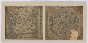
Joseon yojido
48.
Kawahe or Vincennes Island, Paumoto Group ; Raraka Island, Paumotu Group
49.
King Georges Group ; Aratica or Carlshoff Island
50.
Location of the Boston & Maine extension rail road : from Boston to Wilmington
51.
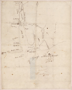
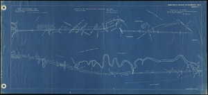
[Manuscript map of coast from Maine to Delaware]
52.
Manuscript maps of U.S. states, possibly drawn by a schoolchild
53.
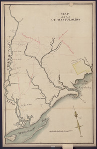
Map of a part of west-Florida : overlay down
54.
Map of a part of west-Florida : overlay up
55.
Map of a woman's heart
56.
Map of an exploring expedition to the Rocky Mountains in the year 1842 and to Oregon & north California in the years 1843-44
57.
Map of Liberia
58.
Map of Mobile Bay
59.
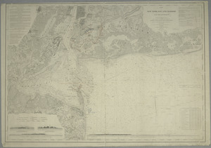
Map of New-York Bay and Harbor and the environs : [with colored manuscript additions to show positions of troops and fleets at...
60.
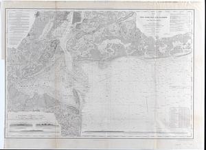
Map of New-York Bay and Harbor and the environs : Founded upon a trigonometrical survey under the direction of F.R. Hassler,...
‹ Prev
Next ›
1
2
3
4
5
6


![[Isthmus of Tehuantepec, Mexico]](https://bpldcassets.blob.core.windows.net/derivatives/images/commonwealth:4m90fj46g/image_thumbnail_300.jpg)


![[Manuscript map of coast from Maine to Delaware]](https://bpldcassets.blob.core.windows.net/derivatives/images/commonwealth:x633f976h/image_thumbnail_300.jpg)