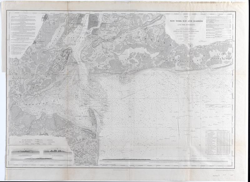
Map of New-York Bay and Harbor and the environs : Founded upon a trigonometrical survey under the direction of F.R. Hassler, superintendent of the Survey of the Coast of the United States
Item Information
- Title:
- Map of New-York Bay and Harbor and the environs : Founded upon a trigonometrical survey under the direction of F.R. Hassler, superintendent of the Survey of the Coast of the United States
- Creator:
- Hassler, F. R. (Ferdinand Rudolph), 1770-1843
- Creator:
- Bache, A. D. (Alexander Dallas), 1806-1867
- Name on Item:
-
Triangulation by James Ferguson and Edmund Blunt, assistants ; the hydrography under the direction of Thomas R. Gedney, Lieutenant U.S. Navy ; the topography by C. Renard, T. A. Jenkins & B.F. Sands, assist. ; engraving supervised & views of the coast drawn by J. Farley
- Date:
-
1845
- Format:
-
Maps/Atlases
- Location:
-
Phillips Academy
Archives and Special Collections - Collection (local):
-
Robert E. Diefenbach Map Collection
- Places:
-
Lower Bay
Upper Bay
New YorkLong Island (island)
- Extent:
- 1 map ; 71 x 95 cm
- Terms of Use:
-
We believe that this item has no known US copyright restrictions. Though not required, if you want to credit us as the source, please use the following statement, "From The Trustees of Phillips Academy." Doing so helps us track how our collection is used and helps justify freely releasing even more content in the future.
This work is in the public domain under a Creative Commons No Rights Reserved License (CC0).
- Publisher:
-
Washington, D.C. :
United States Coast Survey
- Scale:
-
Scale 1:80,000
- Language:
-
English
- Notes:
-
Title from item or accompanying material.
Includes inset views.
- Notes (date):
-
Date from item or accompanying material.
- Identifier:
-
21_219_11