Toggle navigation
LMEC Home
Exhibitions
Georeferencing
Tools for Teachers
Collections
My Favorites
Sign Up / Log In
Search
Search the map portal
Map Collection
Map Collection
Map Sets
Search
Search
Search for
Search In
All Fields
Creator
Title
Subject
Place
Search All Digital Collections
Advanced Search
111 Results
My Search
Start Over
new brunswick
Remove constraint new brunswick
Filter your Search
Place
North and Central America
103
Canada
82
Province of New Brunswick
51
United States
42
Maine
17
Nova Scotia
12
New England
9
Saint John
9
more
Place
»
Topic
New Brunswick--Maps
11
Maine--Maps
8
New England--Maps
7
Canada--Boundaries--United States--Maps
6
Coasts--New Brunswick--Maps
6
Fort Cumberland (N.B.)--Maps, Manuscript--Early works to 1800
6
New Brunswick--Maps--Early works to 1800
6
Nova Scotia--Maps
6
more
Topic
»
Date
Date range begin
–
Date range end
Current results range from
1662
to
1992
View distribution
Creator
Amherst, Jeffery Amherst, Baron, 1717-1797
9
Royal United Services Institute for Defence and Security Studies
9
Des Barres, Joseph F. W. (Joseph Frederick Wallet), 1722-1824
8
George, III, King of Great Britain, 1738-1820
8
George, IV, King of Great Britain, 1762-1830
8
Bruce, Robert George
7
Parr, John, 1725-1791
6
United States. Hydrographic Office
6
more
Creator
»
Format
Maps/Atlases
111
Manuscripts
16
Objects/Artifacts
1
Georeferenced
Yes
5
No
106
Collection
Norman B. Leventhal Map & Education Center Collection
61
American Revolutionary War-Era Maps
58
British Library Collection
17
Boston and New England Maps
14
Maritime Charts and Atlases
11
Library of Congress Collection
10
Urban Maps
10
William L. Clements Library Collection
9
more
Collection
»
Available to use
No known restrictions
60
Creative Commons license
33
Search Constraints
Sort by relevance
relevance
title
date (asc)
date (desc)
Number of results to display per page
20 per page
10
per page
20
per page
50
per page
100
per page
View results as:
grid view
map view
Search Results
41.
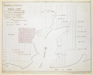
PLAN of the TOWN of BELLE VIEU situated on the East side Beaver Harbour in the District of Passamaquoddy
42.
A PLAN of the TOWN of St ANDREWS Situated at the Head of Passamaquoddy Bay-laid out for the Accomodation of Loyal Emigrants &...
43.
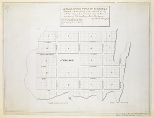
A PLAN OF THE TOWN OF ST. GEORGE Situated in Harbor Etang on the North side the Bay of Fundy, projected and laid out under the...
44.
A new and accurate map of the province of Nova Scotia, in North America; from the latest observations
45.
The environs of Fort Cumberland in the Bay of Fundy
46.
Topographical map of Westmoreland and Albert Counties : from actual surveys by D.J. Lake and H.S. Peck
47.
North America, Bay of Fundy, Grand Manan Island and adjacent coast : from surveys by the British Admiralty in 1855, and by the...
48.
North America : British provinces of New Brunswick, Nova Scotia, & part of Canada : compiled from recent surveys and adjusted...
49.
Explorer's map & directory of the New England Coast : New London, Connecticut, to Passamaquoddy Bay, Canada : a comprehensive...
50.
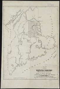
Map of the disputed territory with the boundaries claimed by Maine & Great Britain and that proposed by the King of the...
51.
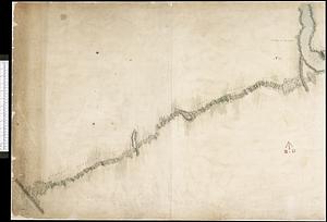
Plan of the river of St. Johns from Fort Frederick in the Bay of Fundy to the river of Medouesqua with the lake of Temescouata...
52.
Map of the state of Maine : exhibiting the disputed territory in connexion with the adjacent British provinces of N. Brunswick...
53.
The harbours of Rishibucto & Buctush : on the west shore of the Gulph of St. Lawrence
54.
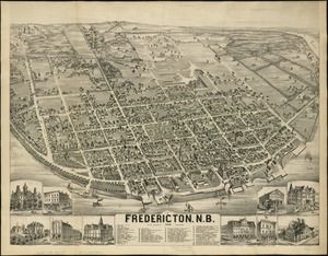
City of Fredericton, N.B
55.
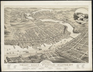
Panoramic view of the city of Calais, St. Stephen and Milltown : Washington Co. Maine, Charlotte Co. New Brunswick : mills,...
56.
The north point of Grandmanan Island in the bay Fundy bearing e.n.e distant two leagues ; A view of Campo Bello at the entrance...
57.
The north point of Grandmanan Island in the bay Fundy bearing e.n.e distant two leagues ; A view of Campo Bello at the entrance...
58.
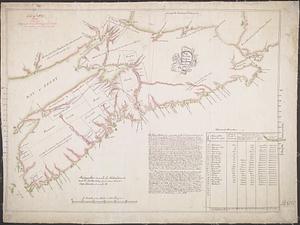
Plan of part of the Province of Nova Scotia or Accadie
59.
Draught of the River Pittquioyack in the Bay of Fundy 1758
60.
A plan of Fort Frederick, situated at the entrance of St. John's River : lat 47 long. 66 30'
‹ Prev
Next ›
1
2
3
4
5
6