Toggle navigation
LMEC Home
Exhibitions
Georeferencing
Tools for Teachers
Collections
My Favorites
Sign Up / Log In
Search
Search the map portal
Map Collection
Map Collection
Map Sets
Search
Search
Search for
Search In
All Fields
Creator
Title
Subject
Place
Search All Digital Collections
Advanced Search
987 Results
My Search
Start Over
More Like
commonwealth-oai:v405x789b
Remove constraint More Like: commonwealth-oai:v405x789b
Filter your Search
Place
North and Central America
959
United States
695
Canada
206
New York
194
Quebec
111
Rhode Island
83
Massachusetts
77
Pennsylvania
61
more
Place
»
Topic
United States--History--Revolution, 1775-1783--Maps
330
United States--History--French and Indian War, 1754-1763--Maps
149
Rhode Island--Maps
50
Saint Lawrence River--Maps
43
Massachusetts--Maps
40
Newport (R.I.)--Maps
28
Connecticut--Maps
26
New York (State)--Maps
25
more
Topic
»
Date
Date range begin
–
Date range end
Current results range from
1700
to
1981
View distribution
Creator
Rocque, Mary Ann
29
Holland, Samuel, 1728-1801
25
Jefferys, Thomas, -1771
25
Montrésor, John, 1736-1799
25
Bellin, Jacques Nicolas, 1703-1772
24
Clinton, Henry, Sir, 1738?-1795
19
Robert Sayer and John Bennett (Firm)
16
Hills, John, active 1777-1819
13
more
Creator
»
Format
Maps/Atlases
971
Drawings/Illustrations
11
Documents
5
Manuscripts
4
Objects/Artifacts
1
Prints
1
Georeferenced
Yes
17
No
970
Collection
American Revolutionary War-Era Maps
934
William L. Clements Library Collection
909
Norman B. Leventhal Map & Education Center Collection
56
Boston and New England Maps
43
American Antiquarian Society Collection
9
David Judkins Weaver Papers
4
Newberry Library Collection
3
Urban Maps
3
more
Collection
»
Available to use
No known restrictions
57
Creative Commons license
5
Search Constraints
Sort by relevance
relevance
title
date (asc)
date (desc)
Number of results to display per page
20 per page
10
per page
20
per page
50
per page
100
per page
View results as:
grid view
map view
Search Results
161.
Plan du combat du 12 Avril 1782 présenté par le chr. Dethy capne. du vass. de roy le Citoyen : Première position des deux...
162.
Plan du siége d'York par l'armée combinée commandée par les generaux Washington et Cte. de Rochambeau
163.
Plan figuratif du combat du 12 Avril 1782 entre l'armée angloise comandée par l'Amiral Rodney ... & l'armée Françoise commandée...
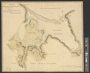
164.
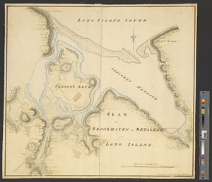
Plan figuratif du combat du 9 Avril 1782 entre l'armée anglaise comandée par l'amiral Rodney ... & l'armée Française commandée...
165.
Plan from Paulus Hook ferry in the province of East Jersey, to King's Ferry in the province of New York and parts adjacent from...
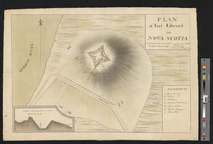
166.
Plan from St. Marys to St. Johns
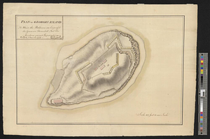
167.
Plan of a fortification who seems necessary on Shutters Folly Island to second the firing of Fort Johnson on any vessel that...
168.
A plan of Boston in New England with its environs, including Milton, Dorchester, Roxbury, Brooklin, Cambridge, Medford,...
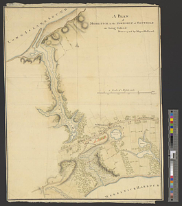
169.
A plan of Brookhaven or Setalket Harbour with its environs
170.
Plan of Brookhaven, or Setalket on Long Island
171.
Plan of Charleston and its defenses 1780
172.
Plan of Charlestown 1781
173.
Plan of Fort Edward in Nova Scotia
174.
Plan of Fort George and adjacent works at Pensacola in West Florida
175.
Plan of Georges Island : NB where the platforms are expres'd the guns are mounted but the merlons are not repaired
176.
Plan of ground about Wilmington
177.
Plan of Isle aux Noix at the north end of Lake Champlain 1780
178.
A plan of Manchac 1774
179.
Plan of Merritck [sic] in the township of Southold on Long Island
180.
A plan of Merritick in the township of Southold on Long Island
‹ Prev
Next ›
1
2
…
5
6
7
8
9
10
11
12
13
…
49
50


![Plan of Merritck [sic] in the township of Southold on Long Island](https://bpldcassets.blob.core.windows.net/derivatives/metadata/commonwealth-oai:8623ns35f/image_thumbnail_300.jpg)