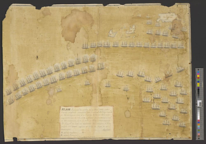
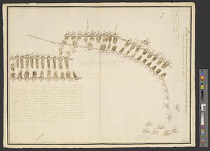
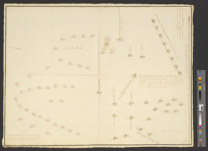
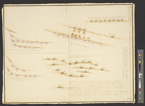
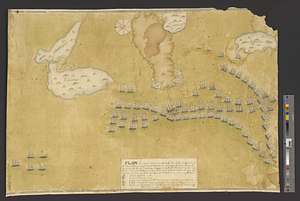
Plan figuratif du combat du 12 Avril 1782 entre l'armée angloise comandée par l'Amiral Rodney ... & l'armée Françoise commandée par Mr. LeCte de Grasse ... par lequel on voit une partie de l'armée Françoise en ligne & l'armée Angloise coupant la ligne sur l'arrière du Glorieux & sur la ligne de l'avant
This map is also available in American Revolutionary Geographies Online (ARGO), a collections portal especially built for material relating to the American Revolutionary War Era. Visit ARGO to learn more about this item and explore the historical geography of North America in the late eighteenth century.
Item Information
- Title:
- Plan figuratif du combat du 12 Avril 1782 entre l'armée angloise comandée par l'Amiral Rodney ... & l'armée Françoise commandée par Mr. LeCte de Grasse ... par lequel on voit une partie de l'armée Françoise en ligne & l'armée Angloise coupant la ligne sur l'arrière du Glorieux & sur la ligne de l'avant
- Creator:
- Martineau, officier du Glorieux
- Name on Item:
-
fecit Martineau, officier du Glorieux
- Date:
-
[1782]
- Format:
-
Maps/Atlases
- Genre:
-
Manuscript maps
- Location:
- William L. Clements Library
- Collection (local):
-
William L. Clements Library Collection
- Subjects:
-
Saintes, Battle of the, Guadeloupe, 1782--Maps
Guadeloupe--Maps
Dominica--Maps
United States--History--Revolution, 1775-1783--Maps
- Places:
-
Guadeloupe (territory)
Dominica
- Extent:
- 1 ms. map : col. ; 44.5 x 64.2 cm.
- Terms of Use:
-
The University of Michigan Library provides access to these materials for educational and research purposes. These materials may be under copyright. If you decide to use any of these materials, you are responsible for making your own legal assessment and securing any necessary permission. If you have questions about the collection, please contact the William L. Clements Library.
Contact host institution for more information.
- Scale:
-
Scale indeterminate.
- Language:
-
French
- Catalog Record:
-
Catalog record
- Notes:
-
Pictorial plan showing the positions of opposing fleets during one phase of the Battle of the Saintes.
Vessels rendered in detail and identified by national flags.
Table of reference provides some additional details.
- Notes (date):
-
This date is inferred.
- Identifier:
-
8682
- Barcode:
-
B3302871