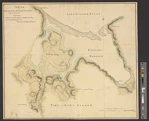
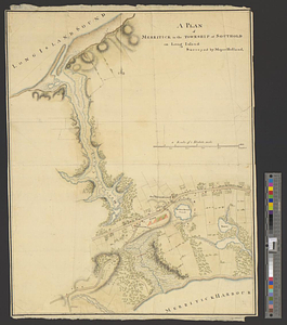
A plan of Merritick in the township of Southold on Long Island
This map is also available in American Revolutionary Geographies Online (ARGO), a collections portal especially built for material relating to the American Revolutionary War Era. Visit ARGO to learn more about this item and explore the historical geography of North America in the late eighteenth century.
Item Information
- Title:
- A plan of Merritick in the township of Southold on Long Island
- Creator:
- Holland, Samuel, 1728-1801
- Name on Item:
-
surveyed by Major Holland
- Date:
-
[1778]
- Format:
-
Maps/Atlases
- Genre:
-
Manuscript maps
- Location:
- William L. Clements Library
- Collection (local):
-
William L. Clements Library Collection
- Subjects:
-
Southold (N.Y.)--Maps
United States--History--Revolution, 1775-1783--Maps
Tryon, William, 1729-1788
- Places:
-
New YorkSuffolk (county)Southold
- Extent:
- 1 ms. map : col. ; 50.3 x 38.6 cm.
- Terms of Use:
-
The University of Michigan Library provides access to these materials for educational and research purposes. These materials may be under copyright. If you decide to use any of these materials, you are responsible for making your own legal assessment and securing any necessary permission. If you have questions about the collection, please contact the William L. Clements Library.
Contact host institution for more information.
- Scale:
-
Scale 1:12.100.
- Language:
-
English
- Catalog Record:
-
Catalog record
- Notes:
-
Finished, colored, topographical map showing British encampment at Merritick Meeting and General William Tryon's headquarters.
Locations of homes and public buildings have been indicated with property lines defined, and positions of military units are identified by color.
Similar to Clinton Map 126 with similar title.
Clinton Map 125.
- Notes (date):
-
This date is inferred.
- Identifier:
-
851
- Barcode:
-
B2848403