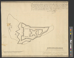
Plan of a fortification who seems necessary on Shutters Folly Island to second the firing of Fort Johnson on any vessel that might have forced her passage through Fort Moultrie & would fetch a passage through the sand bank that extends from Charlestown Point to Shutters Folly : this fortification may easily be erected with (fassing) of sand & wood under which mines could be managed for in case of need have her destroyed ... presented to his excellency Edward Ruttledge ...
This map is also available in American Revolutionary Geographies Online (ARGO), a collections portal especially built for material relating to the American Revolutionary War Era. Visit ARGO to learn more about this item and explore the historical geography of North America in the late eighteenth century.
Item Information
- Title:
- Plan of a fortification who seems necessary on Shutters Folly Island to second the firing of Fort Johnson on any vessel that might have forced her passage through Fort Moultrie & would fetch a passage through the sand bank that extends from Charlestown Point to Shutters Folly : this fortification may easily be erected with (fassing) of sand & wood under which mines could be managed for in case of need have her destroyed ... presented to his excellency Edward Ruttledge ...
- Title (alt.):
-
Draught of elevation of a battery on an angle of the fortification constructed of wood and sand bearing 14 feet above the surface of the sea without including her foundation
- Creator:
- Philip, Pierre
- Name on Item:
-
Pre Philip
- Date:
-
[1770–1779]
- Format:
-
Maps/Atlases
- Genre:
-
Manuscript maps
- Location:
- William L. Clements Library
- Collection (local):
-
William L. Clements Library Collection
- Subjects:
-
Fortification--Maps
Shutes Folly Island (Charleston, S.C.)--Maps
United States--History--Revolution, 1775-1783--Maps
Rutledge, Edward, 1749-1800
- Places:
-
South CarolinaCharleston (county)Shutes Folly Island (island)
- Extent:
- 1 ms. map ; 42.3 x 50 cm
- Terms of Use:
-
The University of Michigan Library provides access to these materials for educational and research purposes. These materials may be under copyright. If you decide to use any of these materials, you are responsible for making your own legal assessment and securing any necessary permission. If you have questions about the collection, please contact the William L. Clements Library.
Contact host institution for more information.
- Scale:
-
Scale ca. 1:1,540.
- Language:
-
English
- Catalog Record:
-
Catalog record
- Notes:
-
Proposed fortification for island in Charleston harbor.
Inset shows elevation of battery wall.
Clinton Maps 315.
- Notes (date):
-
This date is inferred.
- Identifier:
-
8318
- Barcode:
-
B1938682


