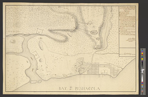
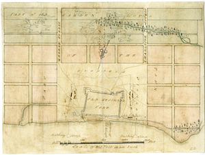
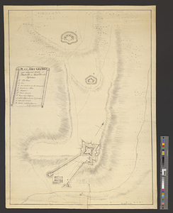
Plan of Fort George and adjacent works at Pensacola in West Florida
This map is also available in American Revolutionary Geographies Online (ARGO), a collections portal especially built for material relating to the American Revolutionary War Era. Visit ARGO to learn more about this item and explore the historical geography of North America in the late eighteenth century.
Item Information
- Title:
- Plan of Fort George and adjacent works at Pensacola in West Florida
- Creator:
- Heldring, Henry
- Name on Item:
-
Henry Heldring capt: 3d. Regt of Waldeck & engineer at Pensacola
- Date:
-
[1781]
- Format:
-
Maps/Atlases
- Genre:
-
Manuscript maps
- Location:
- William L. Clements Library
- Collection (local):
-
William L. Clements Library Collection
- Subjects:
-
Fort George (Fla. : Fort)--Maps
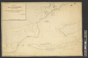
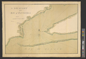
Pensacola (Fla.)--Maps
Pensacola (Fla.)--Capture, 1781--Maps
United States--History--Revolution, 1775-1783--Maps
- Places:
-
FloridaEscambia (county)Pensacola
- Extent:
- 1 ms. map ; 63.2 x 45 cm
- Terms of Use:
-
The University of Michigan Library provides access to these materials for educational and research purposes. These materials may be under copyright. If you decide to use any of these materials, you are responsible for making your own legal assessment and securing any necessary permission. If you have questions about the collection, please contact the William L. Clements Library.
Contact host institution for more information.
- Scale:
-
Scale 1:1,800.
- Language:
-
English
- Catalog Record:
-
Catalog record
- Notes:
-
Finished, topographical, pen and ink map showing ground plan of the fort and nearby redoubts.
Table of references identifies features of the fortifications.
Clinton Maps 338.
- Notes (date):
-
This date is inferred.
- Identifier:
-
579
- Barcode:
-
B1938835