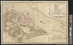
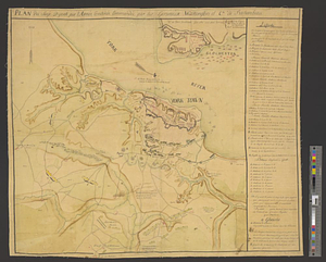
Plan du siége d'York par l'armée combinée commandée par les generaux Washington et Cte. de Rochambeau
This map is also available in American Revolutionary Geographies Online (ARGO), a collections portal especially built for material relating to the American Revolutionary War Era. Visit ARGO to learn more about this item and explore the historical geography of North America in the late eighteenth century.
Item Information
- Title:
- Plan du siége d'York par l'armée combinée commandée par les generaux Washington et Cte. de Rochambeau
- Date:
-
[ca. 1781]
- Format:
-
Maps/Atlases
- Genre:
-
Manuscript maps
- Location:
- William L. Clements Library
- Collection (local):
-
William L. Clements Library Collection
- Subjects:
-
Yorktown (Va.)--Maps
Yorktown (Va.)--History--Siege, 1781--Maps
United States--History--Revolution, 1775-1783--Maps
- Places:
-
VirginiaYork (county)Yorktown
- Extent:
- 1 ms. map : col. ; 53.5 x 59 cm
- Terms of Use:
-
The University of Michigan Library provides access to these materials for educational and research purposes. These materials may be under copyright. If you decide to use any of these materials, you are responsible for making your own legal assessment and securing any necessary permission. If you have questions about the collection, please contact the William L. Clements Library.
Contact host institution for more information.
- Scale:
-
Scale indeterminate.
- Language:
-
French
- Catalog Record:
-
Catalog record
- Notes:
-
Finished, colored topographical map showing positions of opposing military units after the completion of the second parallel.
Extensive table of references to features and events of the siege.
Clinton Maps 268.
- Identifier:
-
8670
- Barcode:
-
B1937157