Toggle navigation
LMEC Home
Exhibitions
Georeferencing
Tools for Teachers
Collections
My Favorites
Sign Up / Log In
Search
Search the map portal
Map Collection
Map Collection
Map Sets
Search
Search
Search for
Search In
All Fields
Creator
Title
Subject
Place
Search All Digital Collections
Advanced Search
987 Results
My Search
Start Over
More Like
commonwealth-oai:v405x789b
Remove constraint More Like: commonwealth-oai:v405x789b
Filter your Search
Place
North and Central America
959
United States
695
Canada
206
New York
194
Quebec
111
Rhode Island
83
Massachusetts
77
Pennsylvania
61
more
Place
»
Topic
United States--History--Revolution, 1775-1783--Maps
330
United States--History--French and Indian War, 1754-1763--Maps
149
Rhode Island--Maps
50
Saint Lawrence River--Maps
43
Massachusetts--Maps
40
Newport (R.I.)--Maps
28
Connecticut--Maps
26
New York (State)--Maps
25
more
Topic
»
Date
Date range begin
–
Date range end
Current results range from
1700
to
1981
View distribution
Creator
Rocque, Mary Ann
29
Holland, Samuel, 1728-1801
25
Jefferys, Thomas, -1771
25
Montrésor, John, 1736-1799
25
Bellin, Jacques Nicolas, 1703-1772
24
Clinton, Henry, Sir, 1738?-1795
19
Robert Sayer and John Bennett (Firm)
16
Hills, John, active 1777-1819
13
more
Creator
»
Format
Maps/Atlases
971
Drawings/Illustrations
11
Documents
5
Manuscripts
4
Objects/Artifacts
1
Prints
1
Georeferenced
Yes
17
No
970
Collection
American Revolutionary War-Era Maps
934
William L. Clements Library Collection
909
Norman B. Leventhal Map & Education Center Collection
56
Boston and New England Maps
43
American Antiquarian Society Collection
9
David Judkins Weaver Papers
4
Newberry Library Collection
3
Urban Maps
3
more
Collection
»
Available to use
No known restrictions
57
Creative Commons license
5
Search Constraints
Sort by relevance
relevance
title
date (asc)
date (desc)
Number of results to display per page
20 per page
10
per page
20
per page
50
per page
100
per page
View results as:
grid view
map view
Search Results
1.
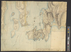
Newport and its environs, ca. 1778
2.
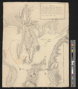
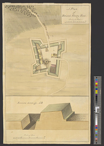
Plan of the adjacent coast to the northern part of Rhode Island, to express the route of a body of troops under the command of...
3.
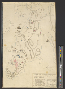
Plan of the position of his majesty's troops at Rhode Island, after the defeat of the rebels the 29th of August 1778
4.
Plan of the town and environs of Newport, Rhode Island : exhibiting its defenses formed before the 8th of August 1778 when the...
5.
Plan of the town and environs of Newport, Rhode Island : exhibiting its defenses formed before the 8th of August 1778 when the...
6.
Plan of the works, which form the exterior line of defence, for the town of New-Port in Rhode Island : also of the batteries...
7.
A chart of the harbour of Rhode Island and Narraganset Bay surveyed in pursuance of directions from the Lords of Trade to His...
8.
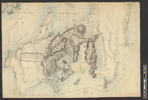
Narragansett Bay and Rhode Island
9.
Newport County, ca. 1779
10.
Plan de la baie de Narragansett dans la Nouvelle Angleterre avec toutes les îles qu'elle renferme parmi lesquelles se trouvent...
11.
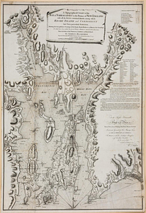
A topographical chart of the bay of Narraganset in the province of New England, with all the isles contained therein, among...
12.
A chart of the harbour of Rhode Island and Narraganset Bay surveyed in pursuance of directions from the Lords of Trade to his...
13.
A chart of the harbour of Rhode Island and Narraganset Bay surveyed in pursuance of directions from the Lords of Trade to his...
14.
A draft of the Nerernanset shore from the entrance to the mouth of Potewomet River northward and from the Nererganset Bay to...
15.
A draught of Rhode Island, 1777
16.
Original plan of Brentons Neck; and all the ground to the southward of the town of New-port Rhode Island, 1779
17.
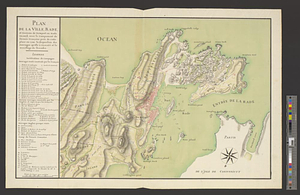
Plan de la ville, rade, et environs de Newport en Rode Island, avec le campement de l'armée Françoise prés de cette place en...
18.
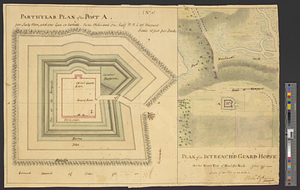
Plan of an intrench'd guard house at the north end of Howlands Neck, June 1777
19.
A plan of Bristol Ferry fort
20.
Plan of Fort Brown, for 4 guns en barbette; with a small redout, and a line for 60 men, and a barrack
‹ Prev
Next ›
1
2
3
4
5
…
49
50