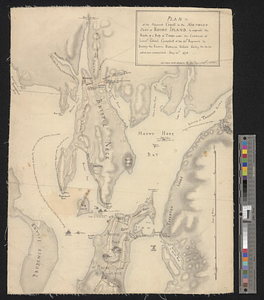
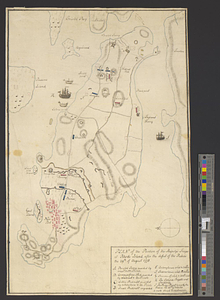
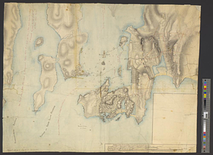
Newport and its environs, ca. 1778
This map is also available in American Revolutionary Geographies Online (ARGO), a collections portal especially built for material relating to the American Revolutionary War Era. Visit ARGO to learn more about this item and explore the historical geography of North America in the late eighteenth century.
Item Information
- Title:
- Newport and its environs, ca. 1778
- Creator:
- Fage, Edward
- Date:
-
[ca. 1778]
- Format:
-
Maps/Atlases
- Genre:
-
Manuscript maps
- Location:
- William L. Clements Library
- Collection (local):
-
William L. Clements Library Collection
- Subjects:
-
Rhode Island, Battle of, R.I., 1778--Maps
Newport (R.I.)--Maps
United States--History--Revolution, 1775-1783--Maps
- Places:
-
Rhode IslandNewport (county)Newport
- Extent:
- 1 ms. map : col. ; 48.5 x 59.7 cm.
- Terms of Use:
-
The University of Michigan Library provides access to these materials for educational and research purposes. These materials may be under copyright. If you decide to use any of these materials, you are responsible for making your own legal assessment and securing any necessary permission. If you have questions about the collection, please contact the William L. Clements Library.
Contact host institution for more information.
- Scale:
-
Scale 1:24,000.
- Language:
-
English
- Catalog Record:
-
Catalog record
- Notes:
-
Unfinished, colored, topographical map of the southwestern section of the island of Rhode Island showing the town and its immediate vicinity.
Fortifications and positions of British troops during the attack of 1778 are shown.
Additional notations record the movements of French naval vessels during the attack.
Attributed to Fage by style.
Clinton Map 66.
- Identifier:
-
8380
- Barcode:
-
B2849764