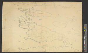
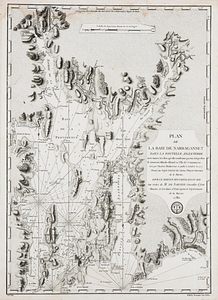
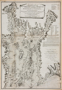
A chart of the harbour of Rhode Island and Narraganset Bay surveyed in pursuance of directions from the Lords of Trade to His Majesty's surveyor general for the northern district of North America : published at the request of the Right Honourable Lord Viscount Howe

This map is also available in American Revolutionary Geographies Online (ARGO), a collections portal especially built for material relating to the American Revolutionary War Era. Visit ARGO to learn more about this item and explore the historical geography of North America in the late eighteenth century.
Item Information
- Title:
- A chart of the harbour of Rhode Island and Narraganset Bay surveyed in pursuance of directions from the Lords of Trade to His Majesty's surveyor general for the northern district of North America : published at the request of the Right Honourable Lord Viscount Howe
- Creator:
- Des Barres, Joseph F. W. (Joseph Frederick Wallet), 1729-1824
- Name on Item:
-
by J.F.W. Des Barres, Esqr., 20th July 1776
- Date:
-
[1778]
- Format:
-
Maps/Atlases
- Location:
- William L. Clements Library
- Collection (local):
-
William L. Clements Library Collection
- Subjects:
-
Narragansett Bay (R.I.)--Maps
Newport County (R.I.)--Maps
Newport (R.I.)--Maps
United States--History--Revolution, 1775-1783--Maps
- Places:
-
Rhode IslandBristol (county)Narragansett Bay
Rhode IslandNewport (county)
Rhode IslandNewport (county)Newport
- Extent:
- 1 map : col. ; 107.6 x 75.2 cm
- Terms of Use:
-
The University of Michigan Library provides access to these materials for educational and research purposes. These materials may be under copyright. If you decide to use any of these materials, you are responsible for making your own legal assessment and securing any necessary permission. If you have questions about the collection, please contact the William L. Clements Library.
Contact host institution for more information.
- Publisher:
-
[London] :
Publish'd according to act, May 3, 1776, by J.F.W. Des Barres, Esqr.
- Scale:
-
Scale [ca. 1:52,000].
- Language:
-
English
- Catalog Record:
-
Catalog record
- Notes:
-
Relief shown by shading and hachures. Depths shown pictorially and by soundings.
State includes table of reference to the position of British ships and forces after the July 29th, 1778 landing of the French fleet, through August 9th, 1778.
In: Des Barres, J. Charts of the coast and harbors of New England. London, 1778. No. 14.
- Notes (date):
-
This date is inferred.
- Identifier:
-
801
- Barcode:
-
B6206715