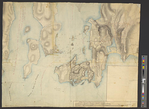
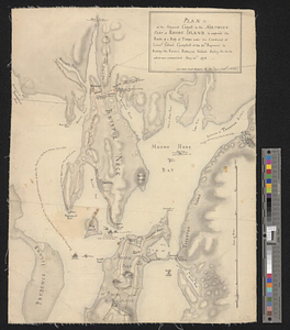
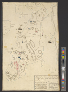
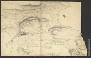
Plan of the town and environs of Newport, Rhode Island : exhibiting its defenses formed before the 8th of August 1778 when the French fleet engaged and passed the batteries, the course of the French fleet up the harbor, the rebel attack and such defensive works as were erected since that day untill the 29th of August when the siege was raised; also the works proposed to be erected in the present year 1779
This map is also available in American Revolutionary Geographies Online (ARGO), a collections portal especially built for material relating to the American Revolutionary War Era. Visit ARGO to learn more about this item and explore the historical geography of North America in the late eighteenth century.
Item Information
- Title:
- Plan of the town and environs of Newport, Rhode Island : exhibiting its defenses formed before the 8th of August 1778 when the French fleet engaged and passed the batteries, the course of the French fleet up the harbor, the rebel attack and such defensive works as were erected since that day untill the 29th of August when the siege was raised; also the works proposed to be erected in the present year 1779
- Creator:
- Aubant, Abraham d'
- Date:
-
1779
- Format:
-
Maps/Atlases
- Genre:
-
Manuscript maps
- Location:
- William L. Clements Library
- Collection (local):
-
William L. Clements Library Collection
- Subjects:
-
Rhode Island, Battle of, R.I., 1778--Maps
Newport (R.I.)--Maps
United States--History--Revolution, 1775-1783--Maps
- Places:
-
Rhode IslandNewport (county)Newport
- Extent:
- 1 ms. map on 2 sheets : col. ; 130.5 x 107 cm.
- Terms of Use:
-
The University of Michigan Library provides access to these materials for educational and research purposes. These materials may be under copyright. If you decide to use any of these materials, you are responsible for making your own legal assessment and securing any necessary permission. If you have questions about the collection, please contact the William L. Clements Library.
Contact host institution for more information.
- Scale:
-
Scale 1:6,000.
- Language:
-
English
- Catalog Record:
-
Catalog record
- Notes:
-
Signed below explanations: Am: D'Aubant, commanding engineer.
Finished, colored, topographical map of the lower part of the island of Rhode Island and part of Conanicut Island showing defensive fortifications and rebel siege lines.
Positions of British and German units are shown by color and identified by number or name.
Extensive table of explanations describes fortifications existing in 1778, armament of the rebel siege lines, and new works projected for construction in 1779.
Clinton Map 70.
- Identifier:
-
6052
- Barcode:
-
B2852811