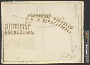
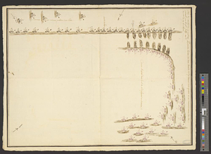
Plan du combat du 12 Avril 1782 présenté par le chr. Dethy capne. du vass. de roy le Citoyen : Première position des deux armées à sept heurs trois quarte et au commencement du feu
This map is also available in American Revolutionary Geographies Online (ARGO), a collections portal especially built for material relating to the American Revolutionary War Era. Visit ARGO to learn more about this item and explore the historical geography of North America in the late eighteenth century.
Item Information
- Title:
- Plan du combat du 12 Avril 1782 présenté par le chr. Dethy capne. du vass. de roy le Citoyen : Première position des deux armées à sept heurs trois quarte et au commencement du feu
- Creator:
- D'Ethy, captain
- Former owner:
- Castries, Charles Eugène Gabriel de La Croix, marquis de, 1727-1801
- Date:
-
[1782]
- Format:
-
Maps/Atlases
- Genre:
-
Manuscript maps
- Location:
- William L. Clements Library
- Collection (local):
-
William L. Clements Library Collection
- Subjects:
-
Saintes, Battle of the, Guadeloupe, 1782--Maps
Guadeloupe--Maps
United States--History--Revolution, 1775-1783--Maps
- Places:
-
Guadeloupe (territory)
- Extent:
- 1 ms. map : col. ; 54.7 x 42.7 cm.
- Terms of Use:
-
The University of Michigan Library provides access to these materials for educational and research purposes. These materials may be under copyright. If you decide to use any of these materials, you are responsible for making your own legal assessment and securing any necessary permission. If you have questions about the collection, please contact the William L. Clements Library.
Contact host institution for more information.
- Scale:
-
Scale indeterminate.
- Language:
-
French
- Catalog Record:
-
Catalog record
- Notes:
-
From the Castries Papers (Clements Library).
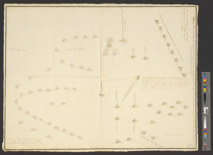
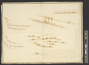
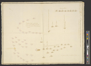
Pen and ink sketch map, one of eight showing successive phases of the Battle of the Saintes.
Ships shown by sketches, with opposing forces differentiated by color and some vessels identified by name.
- Notes (date):
-
This date is inferred.
- Identifier:
-
8677
- Barcode:
-
B3302778