Toggle navigation
LMEC Home
Exhibitions
Georeferencing
Tools for Teachers
Collections
My Favorites
Sign Up / Log In
Search
Search the map portal
Map Collection
Map Collection
Map Sets
Search
Search
Search for
Search In
All Fields
Creator
Title
Subject
Place
Search All Digital Collections
Advanced Search
937 Results
My Search
Start Over
More Like
commonwealth-oai:bv73gz08m
Remove constraint More Like: commonwealth-oai:bv73gz08m
Filter your Search
Place
North and Central America
911
United States
651
Canada
205
New York
196
Quebec
111
Pennsylvania
65
New Jersey
57
Nova Scotia
48
more
Place
»
Topic
United States--History--Revolution, 1775-1783--Maps
305
United States--History--French and Indian War, 1754-1763--Maps
149
Saint Lawrence River--Maps
43
New York (State)--Maps
29
Middle Atlantic States--Maps
27
Newport (R.I.)--Maps
27
Pennsylvania--Maps
24
Hudson River (N.Y. and N.J.)--Maps
21
more
Topic
»
Date
Date range begin
–
Date range end
Current results range from
1700
to
1969
View distribution
Creator
Rocque, Mary Ann
29
Holland, Samuel, 1728-1801
25
Jefferys, Thomas, -1771
25
Montrésor, John, 1736-1799
25
Bellin, Jacques Nicolas, 1703-1772
24
Clinton, Henry, Sir, 1738?-1795
19
Robert Sayer and John Bennett (Firm)
16
Hills, John, active 1777-1819
13
more
Creator
»
Format
Maps/Atlases
921
Drawings/Illustrations
11
Documents
5
Manuscripts
1
Prints
1
Georeferenced
Yes
5
No
932
Collection
American Revolutionary War-Era Maps
916
William L. Clements Library Collection
909
Norman B. Leventhal Map & Education Center Collection
21
MacLean Collection Map Library
6
New York Public Library Collection
1
Available to use
No known restrictions
21
Creative Commons license
1
Search Constraints
Sort by relevance
relevance
title
date (asc)
date (desc)
Number of results to display per page
20 per page
10
per page
20
per page
50
per page
100
per page
View results as:
grid view
map view
Search Results
581.
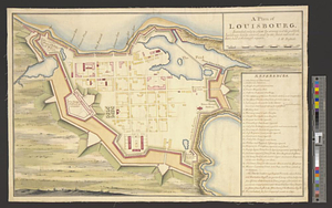
A plan of Louisbourg : intended only to shew by strong red the publick buildings lately erected; and by the faint red such as...
582.
A plan of Louisbourg survey'd and drawn for his excellency the honble. Major General Thos. Gage commander in chief of his...
583.
A plan of Louisbourg survey'd and drawn for his excellency the honble. Major General Thos. Gage commander in chief of his...
584.
A plan of Manchac 1774
585.
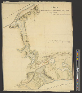
Plan of Merritck [sic] in the township of Southold on Long Island
586.
A plan of Merritick in the township of Southold on Long Island
587.
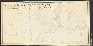
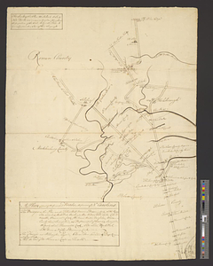
Plan of Middlesex County in the province of East Jersey : copied from the original by Lieut. I. Hills, asst. engr.
588.
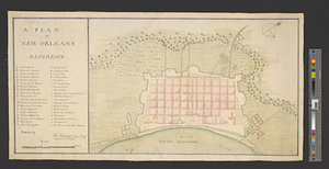
A plan of New Orleans
589.
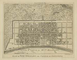
Plan of New Orleans the capital of Louisiana
590.
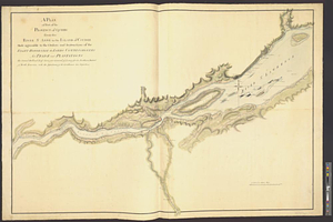
A plan of New York Island with the circumjacent country as far as Dobb's Ferry to the north, and White-Plains the the east;...
591.
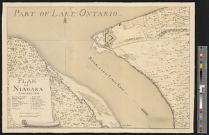
Plan of Niagara
592.
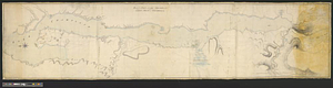
Plan of Niagara River between the Lakes Ontario and Erie
593.
Plan of part of Fort George, with the barracks &c. erected in the year 1759 : situated lat. 4 30' long. 73 30'
594.
Plan of part of Lake Champlain from Crown Point to Tienderoga
595.
A plan of part of the principal roads in the province of No. Carolina
596.
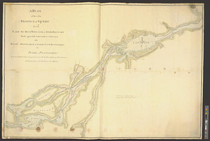
A plan of part of the province of Quebec from the Lake de Deux Montagne to River Batiscant made agreeable to the orders &...
597.
A plan of part of the province of Quebec from the river St. Anne to the island of Coudre made agreeable to the orders and...
598.
Plan of part of the province of Virginia
599.
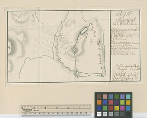
Plan of Pauls-Hoock and the works thereon : by ordre of Lieut. Collonel Emmerick commandant
600.
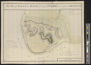
Plan of Paulus Hook shewing the works erected for its defence
‹ Prev
Next ›
1
2
…
26
27
28
29
30
31
32
33
34
…
46
47

![Plan of Merritck [sic] in the township of Southold on Long Island](https://bpldcassets.blob.core.windows.net/derivatives/metadata/commonwealth-oai:8623ns35f/image_thumbnail_300.jpg)