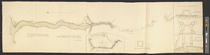
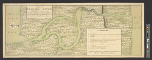
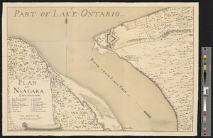
Plan of Niagara River between the Lakes Ontario and Erie

This map is also available in American Revolutionary Geographies Online (ARGO), a collections portal especially built for material relating to the American Revolutionary War Era. Visit ARGO to learn more about this item and explore the historical geography of North America in the late eighteenth century.
Item Information
- Title:
- Plan of Niagara River between the Lakes Ontario and Erie
- Creator:
- Ratzer, Bernard
- Date:
-
[1764]
- Format:
-
Maps/Atlases
- Genre:
-
Manuscript maps
- Location:
- William L. Clements Library
- Collection (local):
-
William L. Clements Library Collection
- Subjects:
-
Pontiac's Conspiracy, 1763-1765--Maps
Niagara River (N.Y. and Ont.)--Maps
Old Fort Niagara (N.Y.)--Maps
Fort Erie (Ont.)--Maps
Niagara Falls (N.Y. and Ont.)--Maps
Navy Island (Ont.)--Maps
- Places:
-
Niagara River
New YorkNiagara (county)Old Fort Niagara
CanadaOntario (province)Fort Erie
Niagara Falls (waterfall)
CanadaOntario (province)Navy Island (island)
- Extent:
- 1 ms. map : col. ; 70.5 x 211.5 cm.
- Terms of Use:
-
The University of Michigan Library provides access to these materials for educational and research purposes. These materials may be under copyright. If you decide to use any of these materials, you are responsible for making your own legal assessment and securing any necessary permission. If you have questions about the collection, please contact the William L. Clements Library.
Contact host institution for more information.
- Scale:
-
Scale 1:24,500.
- Language:
-
English
- Catalog Record:
-
Catalog record
- Notes:
-
Signed: Survey'd by Lt. Ratzer.
Shows length of Niagara River in great detail.
See Ratzer to Gage, July 10, 1764 in Gage Papers (Clements Library).
- Notes (date):
-
This date is inferred.
- Identifier:
-
856
- Barcode:
-
B1936315