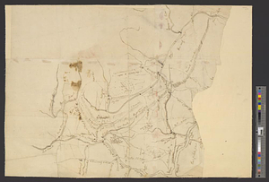
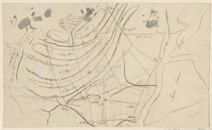
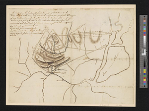
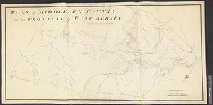
Plan of Middlesex County in the province of East Jersey : copied from the original by Lieut. I. Hills, asst. engr.
This map is also available in American Revolutionary Geographies Online (ARGO), a collections portal especially built for material relating to the American Revolutionary War Era. Visit ARGO to learn more about this item and explore the historical geography of North America in the late eighteenth century.
Item Information
- Title:
- Plan of Middlesex County in the province of East Jersey : copied from the original by Lieut. I. Hills, asst. engr.
- Contributor:
- Hills, John, active 1777-1819
- Creator:
- Dunham, Azariah, 1718-1790
- Name on Item:
-
by Az. Dunham in 1766
- Date:
-
[1770–1779]
- Format:
-
Maps/Atlases
- Genre:
-
Manuscript maps
- Location:
- William L. Clements Library
- Collection (local):
-
William L. Clements Library Collection
- Subjects:
-
Real property--New Jersey--Middlesex County--Maps
Middlesex County (N.J.)--Maps
United States--History--Revolution, 1775-1783--Maps
- Places:
-
New JerseyMiddlesex (county)
- Extent:
- 1 ms. map : col. ; 80 x 156 cm.
- Terms of Use:
-
The University of Michigan Library provides access to these materials for educational and research purposes. These materials may be under copyright. If you decide to use any of these materials, you are responsible for making your own legal assessment and securing any necessary permission. If you have questions about the collection, please contact the William L. Clements Library.
Contact host institution for more information.
- Scale:
-
Scale of chains.
- Language:
-
English
- Catalog Record:
-
Catalog record
- Notes:
-
Finished, partly colored topographical map of the area from Princeton to Amboy.
Houses shown and some property boundaries, with names of owners, appear in the vicinity of the Raritan River.
Clinton Maps 228.
- Notes (date):
-
This date is inferred.
- Identifier:
-
8298
- Barcode:
-
B2667814