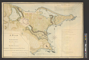
A plan of Louisbourg survey'd and drawn for his excellency the honble. Major General Thos. Gage commander in chief of his majesty's forces in America &c.
This map is also available in American Revolutionary Geographies Online (ARGO), a collections portal especially built for material relating to the American Revolutionary War Era. Visit ARGO to learn more about this item and explore the historical geography of North America in the late eighteenth century.
Item Information
- Title:
- A plan of Louisbourg survey'd and drawn for his excellency the honble. Major General Thos. Gage commander in chief of his majesty's forces in America &c.
- Creator:
- Sproule, Geo. F. (George F.), 1741-1817
- Name on Item:
-
by Ensn. George Sproule of the 59th Regt.
- Date:
-
[1767]
- Format:
-
Maps/Atlases
- Genre:
-
Manuscript maps
- Location:
- William L. Clements Library
- Collection (local):
-
William L. Clements Library Collection
- Subjects:
-
Louisbourg (N.S.)--Maps
- Places:
-
CanadaNova Scotia (province)Louisbourg
- Extent:
- 1 ms. map with overlay : col. ; 52 x 73 cm
- Terms of Use:
-
The University of Michigan Library provides access to these materials for educational and research purposes. These materials may be under copyright. If you decide to use any of these materials, you are responsible for making your own legal assessment and securing any necessary permission. If you have questions about the collection, please contact the William L. Clements Library.
Contact host institution for more information.
- Scale:
-
Scale 1:2,400.
- Language:
-
English
- Catalog Record:
-
Catalog record
- Notes:
-
This item contains a movable flap that is shown in both positions, open and closed.
Finished, colored, topographical map showing the town in great detail with the fortifications demolished.
Overlay shows plan for a small citadel proposed to be constructed over the former citadel.
Table of references identifies major buildings and those structures standing and in ruins.
Enclosed in Samuel Holland to Gage, July 2, 1767.
- Notes (date):
-
This date is inferred.
- Identifier:
-
8242
- Barcode:
-
B1937667


