Toggle navigation
LMEC Home
Exhibitions
Georeferencing
Tools for Teachers
Collections
My Favorites
Sign Up / Log In
Search
Search the map portal
Map Collection
Map Collection
Map Sets
Search
Search
Search for
Search In
All Fields
Creator
Title
Subject
Place
Search All Digital Collections
Advanced Search
1014 Results
My Search
Start Over
More Like
commonwealth-oai:3r078t62x
Remove constraint More Like: commonwealth-oai:3r078t62x
Filter your Search
Place
North and Central America
988
United States
726
Canada
206
New York
201
Quebec
112
Pennsylvania
90
New Jersey
79
Virginia
73
more
Place
»
Topic
United States--History--Revolution, 1775-1783--Maps
308
United States--History--French and Indian War, 1754-1763--Maps
149
Pennsylvania--Maps
50
Virginia--Maps
47
Saint Lawrence River--Maps
43
New Jersey--Maps
40
Maryland--Maps
37
New York (State)--Maps
34
more
Topic
»
Date
Date range begin
–
Date range end
Current results range from
1700
to
1988
View distribution
Creator
Rocque, Mary Ann
29
Bellin, Jacques Nicolas, 1703-1772
26
Holland, Samuel, 1728-1801
26
Montrésor, John, 1736-1799
25
Jefferys, Thomas, -1771
24
Clinton, Henry, Sir, 1738?-1795
19
Robert Sayer and John Bennett (Firm)
15
Hills, John, active 1777-1819
13
more
Creator
»
Format
Maps/Atlases
998
Drawings/Illustrations
11
Documents
5
Manuscripts
2
Prints
1
Georeferenced
Yes
39
No
975
Collection
American Revolutionary War-Era Maps
934
William L. Clements Library Collection
909
Norman B. Leventhal Map & Education Center Collection
86
Maps from AAS
13
MacLean Collection Map Library
5
Urban Maps
2
David Judkins Weaver Papers
1
New York Public Library Collection
1
Available to use
No known restrictions
86
Creative Commons license
1
Search Constraints
Sort by relevance
relevance
title
date (asc)
date (desc)
Number of results to display per page
20 per page
10
per page
20
per page
50
per page
100
per page
View results as:
grid view
map view
Search Results
841.
A plot of Wm Young's land including Delaware paper mill
842.
Point Levi. Parish of St. Charles
843.
Portsmouth
844.
Portsmouth and Norfolk
845.
Position of the army near Iron Hill
846.
Position of the troops under Earl Cornwallis on the 28 and 29th September 1781; when the enemy first appeared
847.
Positions of the British troops between the Hudson River and the Bronx River at Valentine's Hill
848.
Post road & Kaskutahook
849.
Posts of the Hudson's Bay Company 1790
850.
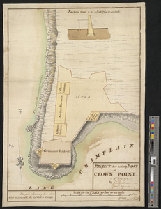
Project for taking post at Crown Point, 13th May 1774 : 13th May 1774
851.
Proposed fortifications for Savannah
852.
Proposed redoubt at Canoe Place
853.
The proposed town of Dartmouth on the Mississippi River
854.
Providence and Newport
855.
The Rahway River valley, ca. 1780
856.
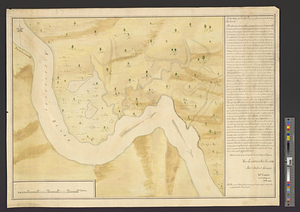
The rapids of the Ohio commonly called the falls 682 miles below Fort Pitt in 38 [degrees]; 08' no. latitude : by order of ye...
857.
Reconnoissance des ouvrages de Ouët Point : etablis pour couvrir et assurer la communication des états du nord avec ceux du...
858.
Region between Westchester Creek and the Bronx River
859.
Region of Gaspee Bay
860.
Region of Hare Island
‹ Prev
Next ›
1
2
…
39
40
41
42
43
44
45
46
47
…
50
51


![The rapids of the Ohio commonly called the falls 682 miles below Fort Pitt in 38 [degrees]; 08' no. latitude](https://bpldcassets.blob.core.windows.net/derivatives/metadata/commonwealth-oai:3x81bj69w/image_thumbnail_300.jpg)