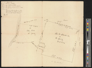
A plot of Wm Young's land including Delaware paper mill
This map is also available in American Revolutionary Geographies Online (ARGO), a collections portal especially built for material relating to the American Revolutionary War Era. Visit ARGO to learn more about this item and explore the historical geography of North America in the late eighteenth century.
Item Information
- Title:
- A plot of Wm Young's land including Delaware paper mill
- Title (alt.):
-
Plot of William Young's land including Delaware paper mill
- Creator:
- Grave, Jacob
- Date:
-
September 5, 1798
- Format:
-
Maps/Atlases
- Genre:
-
Manuscript maps
- Location:
- William L. Clements Library
- Collection (local):
-
William L. Clements Library Collection
- Subjects:
-
Real property--Pennsylvania--Chester County--Maps
Chester County (Pa.)--Maps
Young, William, 1755-1829
- Places:
-
PennsylvaniaChester (county)
- Extent:
- 1 ms. map ; 32.6 x 38 cm
- Terms of Use:
-
The University of Michigan Library provides access to these materials for educational and research purposes. These materials may be under copyright. If you decide to use any of these materials, you are responsible for making your own legal assessment and securing any necessary permission. If you have questions about the collection, please contact the William L. Clements Library.
Contact host institution for more information.
- Scale:
-
Scale indeterminate.
- Language:
-
English
- Catalog Record:
-
Catalog record
- Notes:
-
From William Young Papers (Clements Library).
Title from verso.
Signed: Surveyed the 5th of 9th mo 1798 Jacob Grave.
Finished, pen and ink survey of plots of land along Brandywine Creek with annotations relating to survey done in 1798.
- Identifier:
-
6297
- Barcode:
-
B1939367