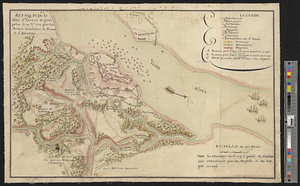
Position of the troops under Earl Cornwallis on the 28 and 29th September 1781; when the enemy first appeared
This map is also available in American Revolutionary Geographies Online (ARGO), a collections portal especially built for material relating to the American Revolutionary War Era. Visit ARGO to learn more about this item and explore the historical geography of North America in the late eighteenth century.
Item Information
- Title:
- Position of the troops under Earl Cornwallis on the 28 and 29th September 1781; when the enemy first appeared
- Date:
-
[1781]
- Format:
-
Maps/Atlases
- Genre:
-
Manuscript maps
- Location:
- William L. Clements Library
- Collection (local):
-
William L. Clements Library Collection
- Subjects:
-
Yorktown (Va.)--Maps
Yorktown (Va.)--History--Siege, 1781--Maps
United States--History--Revolution, 1775-1783--Maps
- Places:
-
VirginiaYork (county)Yorktown
- Extent:
- 1 ms. map : col. ; 77.3 x 54.5 cm.
- Terms of Use:
-
The University of Michigan Library provides access to these materials for educational and research purposes. These materials may be under copyright. If you decide to use any of these materials, you are responsible for making your own legal assessment and securing any necessary permission. If you have questions about the collection, please contact the William L. Clements Library.
Contact host institution for more information.
- Scale:
-
Scale ca. 1:6,000.
- Language:
-
English
- Catalog Record:
-
Catalog record
- Notes:
-
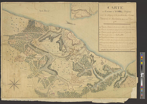
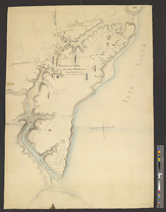
Finished, colored, topographical map of the area from the western edge of the Yorktown defenses to the confluence of Wormley's Creek and the york River.
Individual units are identified by name and by color.
Clinton Maps 273.
- Notes (date):
-
This date is inferred.
- Identifier:
-
558
- Barcode:
-
B2625266