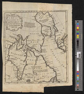
Posts of the Hudson's Bay Company 1790

This map is also available in American Revolutionary Geographies Online (ARGO), a collections portal especially built for material relating to the American Revolutionary War Era. Visit ARGO to learn more about this item and explore the historical geography of North America in the late eighteenth century.
Item Information
- Title:
- Posts of the Hudson's Bay Company 1790
- Date:
-
[ca. 1790]
- Format:
-
Maps/Atlases
- Genre:
-
Manuscript maps
- Location:
- William L. Clements Library
- Collection (local):
-
William L. Clements Library Collection
- Subjects:
-
Hudson Bay--Maps
Manitoba--Maps
Ontario--Maps
Hudson's Bay Company
- Places:
-
CanadaHudson Bay
CanadaProvince of Manitoba (province)
CanadaOntario (province)
- Extent:
- 1 ms. map : outline gray wash ; 24.5 x 32 cm
- Terms of Use:
-
The University of Michigan Library provides access to these materials for educational and research purposes. These materials may be under copyright. If you decide to use any of these materials, you are responsible for making your own legal assessment and securing any necessary permission. If you have questions about the collection, please contact the William L. Clements Library.
Contact host institution for more information.
- Scale:
-
Scale 1:8,000,000.
- Language:
-
English
- Catalog Record:
-
Catalog record
- Notes:
-
From Hudson's Bay Company Papers (Clements Library).
Finished, pen and ink map showing posts on the rivers emptying into Hudson Bay with name of factor given for each post.
- Identifier:
-
8699
- Barcode:
-
B1936994