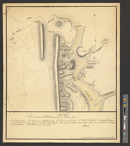
Reconnoissance des ouvrages de Ouët Point : etablis pour couvrir et assurer la communication des états du nord avec ceux du sud, et pour interdire celle du Canada à New York 1781

This map is also available in American Revolutionary Geographies Online (ARGO), a collections portal especially built for material relating to the American Revolutionary War Era. Visit ARGO to learn more about this item and explore the historical geography of North America in the late eighteenth century.
Item Information
- Title:
- Reconnoissance des ouvrages de Ouët Point : etablis pour couvrir et assurer la communication des états du nord avec ceux du sud, et pour interdire celle du Canada à New York 1781
- Title (alt.):
-
Marche sur Princetown et Sommercet par le Général Washington le 2 Janvier 1777 et la surprise de Trenton
Plan de la surprise de Trenton par le Général Washington le 25 7bre [sic] 1777
Reconnoissance des postes de Stonei-pointe et Verplans pointe sur la rivière du Nord à 25 miles du nord de l'isle de New-York, occupés par les Américains
- Creator:
- Colbert, Edouard Charles Victurnien, Comte de Maulevrier, 1758-1820
- Date:
-
[ca. 1783]
- Format:
-
Maps/Atlases
- Genre:
-
Manuscript maps
- Location:
- William L. Clements Library
- Collection (local):
-
William L. Clements Library Collection
- Subjects:
-
Trenton, Battle of, Trenton, N.J., 1776--Maps
Princeton, Battle of, Princeton, N.J., 1777--Maps
West Point (N.Y.)--Maps
Stony Point (N.Y.)--Maps
Verplanck Point (N.Y.)--Maps
United States--History--Revolution, 1775-1783--Maps
- Places:
-
New YorkOrange (county)West Point
New YorkRockland (county)Stony Point (cape)
New YorkWestchester (county)Verplanck Point (cape)
- Extent:
- 1 ms. map : col. ; 42.7 x 62.2 cm.
- Terms of Use:
-
The University of Michigan Library provides access to these materials for educational and research purposes. These materials may be under copyright. If you decide to use any of these materials, you are responsible for making your own legal assessment and securing any necessary permission. If you have questions about the collection, please contact the William L. Clements Library.
Contact host institution for more information.
- Scale:
-
Scale indeterminate.
- Language:
-
French
- Catalog Record:
-
Catalog record
- Notes:
-
Finished, colored, topographical map showing the fortifications of West Point but lacking the references to correspond with the numbers on the map.
Three insets show positions and movements relating to the battles of Trenton and Princeton and the fortifications of Stony and Verplancks Point with 1781 encampments of the French army shown at the latter.
Each inset is accompanied by a table of reference giving details on each position or event.
- Identifier:
-
8685
- Barcode:
-
B2668500