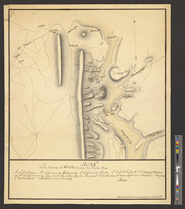
Plan des environs de West Point jusqu'au Croton River... : Morrishous ce 14me Juin 1779
This map is also available in American Revolutionary Geographies Online (ARGO), a collections portal especially built for material relating to the American Revolutionary War Era. Visit ARGO to learn more about this item and explore the historical geography of North America in the late eighteenth century.
Item Information
- Title:
- Plan des environs de West Point jusqu'au Croton River... : Morrishous ce 14me Juin 1779
- Creator:
- Martin, Reinhard Jacob
- Name on Item:
-
Martin
- Date:
-
June 14, 1779
- Format:
-
Maps/Atlases
- Genre:
-
Manuscript maps
- Location:
- William L. Clements Library
- Collection (local):
-
William L. Clements Library Collection
- Subjects:
-
Hudson River (N.Y. and N.J.)--Maps
Castle Clinton (New York, N.Y.)--Maps
Fort Montgomery (N.Y.)--Maps
Stony Point (N.Y.)--Maps
Verplanck Point (N.Y.)--Maps
United States--History--Revolution, 1775-1783--Maps
- Places:
-
Hudson River
New YorkRockland (county)Fort Clinton
New YorkRockland (county)Stony Point (cape)
New YorkWestchester (county)Verplanck Point (cape)
Fort Montgomery (historical)
- Extent:
- 1 ms. map : col. ; 65.3 x 52.1 cm.
- Terms of Use:
-
The University of Michigan Library provides access to these materials for educational and research purposes. These materials may be under copyright. If you decide to use any of these materials, you are responsible for making your own legal assessment and securing any necessary permission. If you have questions about the collection, please contact the William L. Clements Library.
Contact host institution for more information.
- Scale:
-
Scale 1:70,000.
- Language:
-
French
- Catalog Record:
-
Catalog record
- Notes:
-
Finished, colored, topographical wash drawing showing the fortifications in the Hudson Highlands with emphasis on the British posts at Stony and Verplanks points.
Table of references identifies major fortification features.
- Identifier:
-
8405
- Barcode:
-
B2822643


