Portsmouth and Norfolk

This map is also available in American Revolutionary Geographies Online (ARGO), a collections portal especially built for material relating to the American Revolutionary War Era. Visit ARGO to learn more about this item and explore the historical geography of North America in the late eighteenth century.
Item Information
- Title:
- Portsmouth and Norfolk
- Title (alt.):
-
Rebel fort near Portsmouth
- Date:
-
[1770–1779]
- Format:
-
Maps/Atlases
- Genre:
-
Manuscript maps
- Location:
- William L. Clements Library
- Collection (local):
-
William L. Clements Library Collection
- Subjects:
-
Portsmouth (Va.)--Maps
Norfolk (Va.)--Maps
Fort Nelson (Va.)--Maps
United States--History--Revolution, 1775-1783--Maps
- Places:
-
VirginiaPortsmouth
VirginiaNorfolk
- Extent:
- 1 ms. map : col. ; 32 x 39.7 cm.
- Terms of Use:
-
The University of Michigan Library provides access to these materials for educational and research purposes. These materials may be under copyright. If you decide to use any of these materials, you are responsible for making your own legal assessment and securing any necessary permission. If you have questions about the collection, please contact the William L. Clements Library.
Contact host institution for more information.
- Scale:
-
Scale 1:150,000. Scale of inset 1:2,400.
- Language:
-
English
- Catalog Record:
-
Catalog record
- Notes:
-
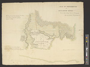
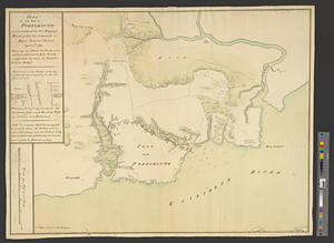
Finished, colored, topographical map showing the area along the Elizabeth River from Norfolk and Portsmouth to New Town and Great Bridge and along the Nansemond River to the town of Suffolk.
Identifies Norfolk as in ruins.
Inset shows Fort Nelson and identifies functions of major buildings.
Unidentified symbols of military units at Portsmouth and other locations might relate to British operations in 1779.
Clinton Maps 282.
- Notes (date):
-
This date is inferred.
- Identifier:
-
8309
- Barcode:
-
B2629926