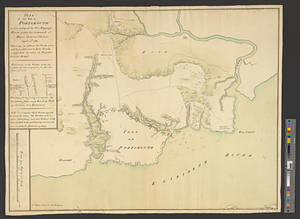
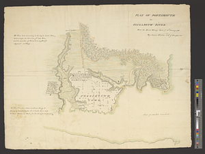
Plan of Portsmouth on Elizabeth River : from an exact survey made ye. 21st January 1781
This map is also available in American Revolutionary Geographies Online (ARGO), a collections portal especially built for material relating to the American Revolutionary War Era. Visit ARGO to learn more about this item and explore the historical geography of North America in the late eighteenth century.
Item Information
- Title:
- Plan of Portsmouth on Elizabeth River : from an exact survey made ye. 21st January 1781
- Creator:
- Straton, James
- Name on Item:
-
by James Straton, 2d lt. of Engineers
- Date:
-
1781
- Format:
-
Maps/Atlases
- Genre:
-
Manuscript maps
- Location:
- William L. Clements Library
- Collection (local):
-
William L. Clements Library Collection
- Subjects:
-
Portsmouth (Va.)--Maps
Fort Nelson (Va.)--Maps
United States--History--Revolution, 1775-1783--Maps
- Places:
-
VirginiaPortsmouth
- Extent:
- 1 ms. map : col. ; 49 x 61.5 cm.
- Terms of Use:
-
The University of Michigan Library provides access to these materials for educational and research purposes. These materials may be under copyright. If you decide to use any of these materials, you are responsible for making your own legal assessment and securing any necessary permission. If you have questions about the collection, please contact the William L. Clements Library.
Contact host institution for more information.
- Scale:
-
Scale 1:6,000.
- Language:
-
English
- Catalog Record:
-
Catalog record
- Notes:
-
Finished, colored topographical map showing the houses in the town and shapes and positions of proposed defensive works for the British occupation.
Enclosed in Benedict Arnold to Henry Clinton, January 23, 1781, Clinton Papers (Clements Library).
Additional notations provide information on defensive positions, size of garrisons needed, and conditions under which map was drawn.
Identifies and describes condition and position of former rebel fort north of the town.
Clinton Maps 277.
- Identifier:
-
8666
- Barcode:
-
B2634839