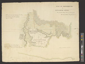
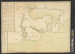
Plan of the post of Portsmouth as it is occupied by his majesty's forces under the command of Major General Phillips, April 1st, 1781 : shewing, in yellow, the works proposed, in addition to those already constructed by order of Brigadier General Arnold
This map is also available in American Revolutionary Geographies Online (ARGO), a collections portal especially built for material relating to the American Revolutionary War Era. Visit ARGO to learn more about this item and explore the historical geography of North America in the late eighteenth century.
Item Information
- Title:
- Plan of the post of Portsmouth as it is occupied by his majesty's forces under the command of Major General Phillips, April 1st, 1781 : shewing, in yellow, the works proposed, in addition to those already constructed by order of Brigadier General Arnold
- Creator:
- Fyers, William
- Date:
-
1781
- Format:
-
Maps/Atlases
- Genre:
-
Manuscript maps
- Location:
- William L. Clements Library
- Collection (local):
-
William L. Clements Library Collection
- Subjects:
-
Portsmouth (Va.)--Maps
United States--History--Revolution, 1775-1783--Maps
- Places:
-
VirginiaPortsmouth
- Extent:
- 1 ms. map : col. ; 51.1 x 65.2 cm.
- Terms of Use:
-
The University of Michigan Library provides access to these materials for educational and research purposes. These materials may be under copyright. If you decide to use any of these materials, you are responsible for making your own legal assessment and securing any necessary permission. If you have questions about the collection, please contact the William L. Clements Library.
Contact host institution for more information.
- Scale:
-
Scale 1:6,000.
- Language:
-
English
- Catalog Record:
-
Catalog record
- Notes:
-
Finished, colored, topographical map showing the area of the town, the outline of its wharves, and the defensive works constructed during the British occupation.
A table of references provides information on the armament of the individual parts of the fortifications.
Clinton Maps 278.
- Identifier:
-
8664
- Barcode:
-
B2625353