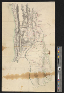
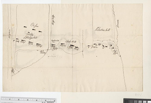
Positions of the British troops between the Hudson River and the Bronx River at Valentine's Hill
This map is also available in American Revolutionary Geographies Online (ARGO), a collections portal especially built for material relating to the American Revolutionary War Era. Visit ARGO to learn more about this item and explore the historical geography of North America in the late eighteenth century.
Item Information
- Title:
- Positions of the British troops between the Hudson River and the Bronx River at Valentine's Hill
- Date:
-
[1778]
- Format:
-
Maps/Atlases
- Genre:
-
Manuscript maps
- Location:
- William L. Clements Library
- Collection (local):
-
William L. Clements Library Collection
- Subjects:
-
Westchester County (N.Y.)--Maps
United States--History--Revolution, 1775-1783--Maps
- Places:
-
New YorkWestchester (county)
- Extent:
- 1 ms. map ; 25.2 x 39.8 cm.
- Terms of Use:
-
The University of Michigan Library provides access to these materials for educational and research purposes. These materials may be under copyright. If you decide to use any of these materials, you are responsible for making your own legal assessment and securing any necessary permission. If you have questions about the collection, please contact the William L. Clements Library.
Contact host institution for more information.
- Scale:
-
Scale [ca. 1:31,200].
- Language:
-
German
- Catalog Record:
-
Catalog record
- Notes:
-
Pen and ink sketch map of German and British regiments involved in the operation, designated by name or number.
Map relates to Gen. Knyphausen's foraging expedition of September 1778.
Clinton Maps 156.
- Notes (date):
-
This date is inferred.
- Identifier:
-
1659
- Barcode:
-
B1936388