Toggle navigation
LMEC Home
Exhibitions
Georeferencing
Tools for Teachers
Collections
My Favorites
Sign Up / Log In
Search
Search the map portal
Map Collection
Map Collection
Map Sets
Search
Search
Search for
Search In
All Fields
Creator
Title
Subject
Place
Search All Digital Collections
Advanced Search
623 Results
My Search
Start Over
More Like
commonwealth:z603vw18x
Remove constraint More Like: commonwealth:z603vw18x
Filter your Search
Place
North and Central America
553
United States
455
New York
113
New Jersey
60
Suffolk (county)
55
Boston
48
Canada
41
Charleston (county)
34
more
Place
»
Topic
United States--History--Revolution, 1775-1783--Maps
330
Newport (R.I.)--Maps
24
North America--Maps--Early works to 1800
18
Boston (Mass.)--History--Revolution, 1775-1783--Maps--Early works to 1800
17
Charleston (S.C.)--Maps
16
Hudson River (N.Y. and N.J.)--Maps
15
New Jersey--Maps
14
Yorktown (Va.)--History--Siege, 1781--Maps
14
more
Topic
»
Date
Date range begin
–
Date range end
Current results range from
1740
to
1881
View distribution
Creator
Faden, William, 1749-1836
41
Jefferys, Thomas, -1771
30
Le Rouge, Georges-Louis
23
Des Barres, Joseph F. W. (Joseph Frederick Wallet), 1722-1824
22
Sayer, Robert, 1725-1794
19
Clinton, Henry, Sir, 1738?-1795
17
Hills, John, active 1777-1819
13
André, John, 1751-1780
11
more
Creator
»
Format
Maps/Atlases
575
Prints
32
Manuscripts
26
Drawings/Illustrations
14
Books
2
Georeferenced
Yes
14
No
609
Collection
American Revolutionary War-Era Maps
616
William L. Clements Library Collection
305
Richard H. Brown Revolutionary War Map Collection at Mount Vernon
293
Boston and New England Maps
9
Norman B. Leventhal Map & Education Center Collection
8
American Antiquarian Society Collection
7
Urban Maps
5
New-York Historical Society Collection
3
more
Collection
»
Available to use
Creative Commons license
295
No known restrictions
11
Search Constraints
Sort by relevance
relevance
title
date (asc)
date (desc)
Number of results to display per page
20 per page
10
per page
20
per page
50
per page
100
per page
View results as:
grid view
map view
Search Results
281.
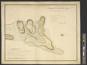
A sketch of Lloyd's Neck : particularly shewing the situation of the redoubt, encampment of the troops, with the ground...
282.
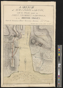
A sketch of New-London or Groton, with the attacks made on Forts Trumbull & Griswold by the British troops under the command of...
283.
A sketch of part of the island of Ste Lucie
284.
Sketch of part of the island of Ste. Lucie : computed at about 2500 feet to 1 inch
285.
A sketch of St. Augustin [sic] Harbour &c.
286.
Sketch of St. Augustine and its environs
287.
Sketch of the attack of Fort Trumbull, and Griswold, near New London in the colony of Connecticut, by a detachment of his...
288.
A sketch of the battle near Camden in South Carolina 16 Augst. 1780
289.
Sketch of the country illustrating the late engagement in Long Island
290.
A sketch of the disposition of the force at New York for the defence of the port
291.
A sketch of the east end of the peninsula where on is Hampton
292.
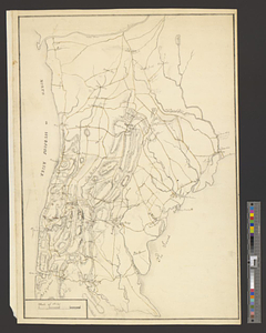
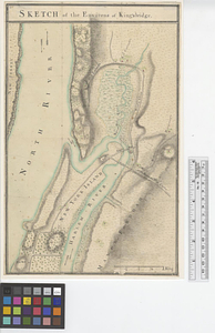
Sketch of the environs of King's bridge
293.
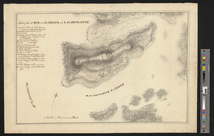
Sketch of the neck and harbour of Majabigwaduce
294.
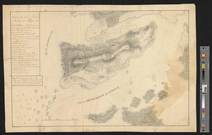
Sketch of the neck and harbour of Majabigwaduce 20th Aug. 1779
295.
Sketch of the position of the army, 17th of June 1780
296.
Sketch of the position of the army on Long Island upon the morning of the 26th of August, 1776; with the march on the ensuing...
297.
Sketch of the position of the British forces at Elizabeth Town Point after their return from Connecticut Farm, in the province...
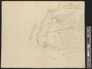
298.
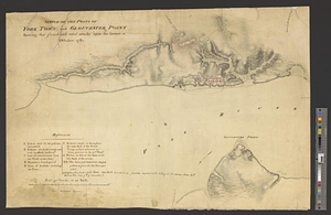
Sketch of the posts of York Town and Gloucester Point shewing the French and rebel attacks upon the former in October, 1781
299.
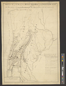
Sketch of the roads from Kings Bridge to the White Plains and parts ajacent shewing the encampment of his majestys forces under...
300.
Sketch of the roads from Kings Bridge to the White Plains and parts ajacent shewing the encampment of his majestys forces under...
‹ Prev
Next ›
1
2
…
11
12
13
14
15
16
17
18
19
…
31
32
![A sketch of St. Augustin [sic] Harbour &c.](https://bpldcassets.blob.core.windows.net/derivatives/metadata/commonwealth-oai:vd670z134/image_thumbnail_300.jpg)

![Sketch of the position of the British forces at Elizabeth Town Point after their return from Connecticut Farm, in the province of East Jersey: under the command of his excelly. Leiutt. [sic] Genl. Knyphausen, on the 8th June 1780](https://bpldcassets.blob.core.windows.net/derivatives/images/commonwealth:z603vn418/image_thumbnail_300.jpg)